
The National Weather Service of Northern Indiana has issued a Winter Storm Warning for Berrien and Cass Counties starting at 2 a.m. on Monday, Jan. 28 and lasting until 7 a.m. on Tuesday, Jan. 29. A Weather Advisory is in effect for the rest of the listening area which will start at 3 a.m. on Monday, Jan. 28 and end at 7 p.m.
WINTER STORM WARNING IN EFFECT FOR BERRIEN AND CASS COUNTIES
WINTER WEATHER ADVISORY IN EFFECT FOR THE REST OF THE MNC LISTENING
AREA.

* WHAT...Snow expected. Total snow accumulations of 3 to 6 inches
  expected with the highest amounts north of the Toll Road. Parts of
  Berrien and Cass Counties could see 8 to 12 inches.

* WHERE...Portions of northern Indiana, southwest Michigan and
  northwest Ohio.

* WHEN...From 3 AM EST /2 AM CST/ to 7 PM EST /6 PM CST/ Monday.

* ADDITIONAL DETAILS...Plan on slippery road conditions. The
  hazardous conditions will likely impact the Monday morning
  commute and possibly the Monday evening commutes. Blowing and
  drifting are likely.

PRECAUTIONARY/PREPAREDNESS ACTIONS...

A Winter Weather Advisory for snow means periods of snow will
cause primarily travel difficulties. Expect snow covered roads
and limited visibilities, and use caution while driving.
Moderate to heavy snow will begin during the overnight hours of Monday. The morning drive could switch to a wintry mix or even rain as temps warm above freezing south of the Indiana Toll Road.
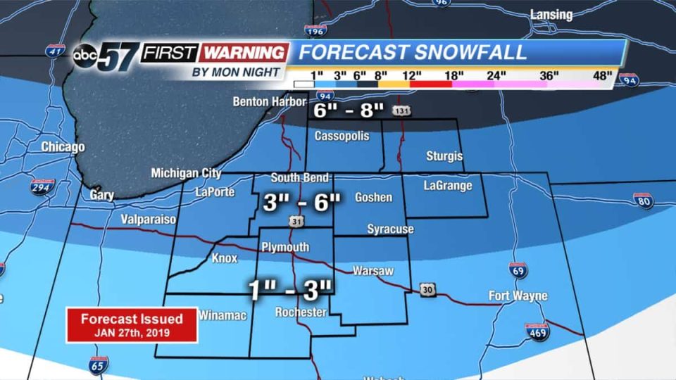
By Monday night, the system snow/mix ends as the lake effect picks back up again. Totals haven’t changed too much with the northern edge of Michiana picking up around 6+”, 3-6” for central Michiana, and 1-3” farther south thanks to the wintry mix chances. Portions of Berrien and Cass Counties could get 8-12″ by early Tuesday morning.
Once the snow clear out, temperatures will drop dramatically and potentially life-threatening and record-breaking cold will set in. The coldest day in the snap is Wednesday, where Michiana’s could see a daytime high of -8 with ’30 to -40 wind chills, which could mean that the coldest all-time high temperature record could be broken this week.
Your ABC 57 First Warning Neighborhood Weather Center Forecast:
Monday: Cloudy with snow and a wintry mix farther south. High of 34.
Tuesday: Mostly cloudy with scattered L.E. snow showers possible. Cold and breezy. Highs near 10 and slowly falling.
Tuesday Night: A 30 percent chance of snow showers before 1am. Mostly cloudy, with a low around -14.
Wednesday: Mostly cloudy and cold, with a high near -10.
Wednesday Night: A 40 percent chance of snow showers after 1am. Mostly cloudy, with a low around -15.
Thursday: A 30 percent chance of snow showers. Partly sunny and cold, with a high near 3.
Thursday Night: A 40 percent chance of snow showers. Mostly cloudy, with a low around -4.
Friday: A 50 percent chance of snow showers. Mostly cloudy and cold, with a high near 17.
Friday Night: Mostly cloudy, with a low around 6.
Saturday: Partly sunny, with a high near 28.