
Lows to start your Monday, Jan. 25, will be in the mid 20s. Highs by the afternoon will be in the low to mid 30s.
A Winter Weather Advisory goes into effect as mixed wintry precipitation and snow showers look to move into Michiana around 5 p.m. – 6 p.m. Snow will remain light at first with a gradual increase into the evening hours.
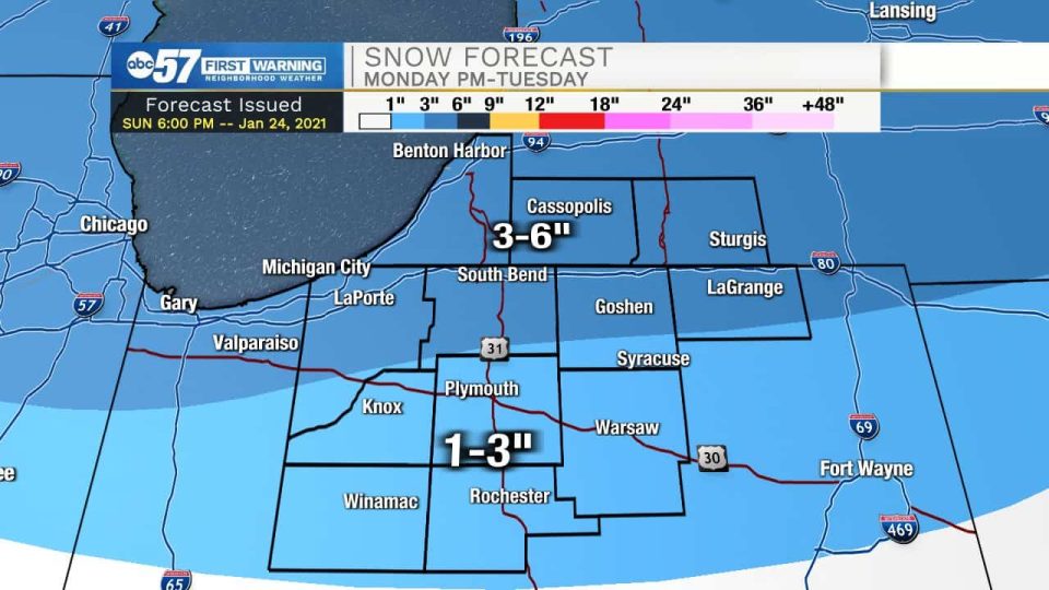
Moderate to heavy snowfall will stick through the overnight hours into Tuesday morning.
During the late morning, Tuesday, we will start to see a downward trend in overall snow intensity. Light snow showers and flurries will remain with us on the back side of the system through 4 p.m. – 5 p.m. on Tuesday. Snow accumulation will range from 3-6 inches in central LaPorte, southern St. Joseph, southern Elkhart, and LaGrange counties northward into Berrien, Cass, and St. Joseph Michigan counties.
Along U.S. 30 and south, 1-3 inches of snow accumulation is possible.
Southern Pulaski and southern Fulton counties could also see up to 0.1” of ice. Slick spots and reduced visibility is likely, especially later in the evening Monday through Tuesday morning.
After the snow moves out cold temperatures will be left behind with lows Thursday and Friday morning in the teens and highs in the 20s. Next weekend another round of wintry mix and snow looks possible.
La Porte-St. Joseph IN-Elkhart-Lagrange-Steuben-Berrien-Cass MI-
St. Joseph MI-Branch-Hillsdale-Williams-Fulton OH-
Including the cities of Michigan City, La Porte, South Bend,
Mishawaka, New Carlisle, Walkerton, Elkhart, Goshen, Nappanee,
Lagrange, Topeka, Shipshewana, Angola, Fremont, Niles,
Benton Harbor, St. Joseph, Fair Plain, Benton Heights, Buchanan,
Paw Paw Lake, Dowagiac, Cassopolis, Marcellus, Sturgis,
Three Rivers, White Pigeon, Mendon, Coldwater, Bronson,
Hillsdale, Jonesville, Litchfield, Bryan, Montpelier, Edgerton,
Wauseon, Archbold, Swanton, and Delta
349 PM EST Sun Jan 24 2021 /249 PM CST Sun Jan 24 2021/

...WINTER WEATHER ADVISORY IN EFFECT FROM 5 PM EST /4 PM CST/
MONDAY TO 1 PM EST /NOON CST/ TUESDAY...

* WHAT...Mixed precipitation expected. Total snow accumulations of
  2 to 5 inches and ice accumulations of a light glaze.

* WHERE...Portions of northern Indiana, southwest Michigan and
  northwest Ohio.

* WHEN...From 5 PM EST /4 PM CST/ Monday to 1 PM EST /noon CST/
  Tuesday.

* IMPACTS...Plan on slippery road conditions. The hazardous
  conditions will likely impact the Tuesday morning commute.

* ADDITIONAL DETAILS...Snow is expected to overspread the area
  Monday evening, with the greatest snowfall rates expected Monday
  mid to late evening. Periods of light snow will likely continue
  into Tuesday.

PRECAUTIONARY/PREPAREDNESS ACTIONS...

Slow down and use caution while traveling.
Your ABC 57 First Warning Neighborhood Weather Center Forecast:
Monday: Snow showers. High 33.
Tuesday: Snow showers. High 32.
Wednesday: Mostly cloudy. High 29.
Thursday: Mostly sunny, with a high near 26.
Friday: Mostly sunny, with a high near 31.