After a very dry past several weeks we are going to be putting together a little bit more of a threat of precipitation as we kick off this first harvest forecast. The weekend clicks off with a fully dry day in most areas on a Saturday. Temperatures remaining above normal but down a little bit from what we saw to finish the week. Meanwhile we are watching a weather system try and move out of the upper Midwest and push into the eastern corn belt.
That weather system is coming into a very dry column of air that sits over the eastern corn belt and the initial amount of moisture that has been in the system raining out over parts of Wisconsin and Illinois the past few days it’s not going to be able to reach the ground in a large part of Indiana or Michigan.
However, we end up with a little bit of moisture trying to pop up over the northern part of Michigan and far western counties of Indiana as we move through Saturday afternoon and evening it might actually be a little bit sooner in northern Michigan and this is just because the initial waves do get through in those areas.
![]()
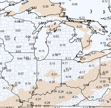
The rest of us are looking at our best chance at precipitation coming later Sunday afternoon and evening and then continuing on through Monday and Tuesday. This moisture won’t be overwhelming on any given day, and it probably starts just a little bit sooner in Michigan than in Indiana due to the fact that we’re seeing two different waves try and come together.
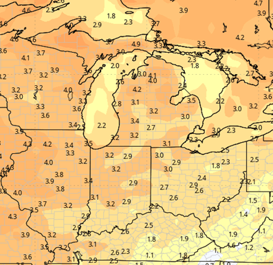
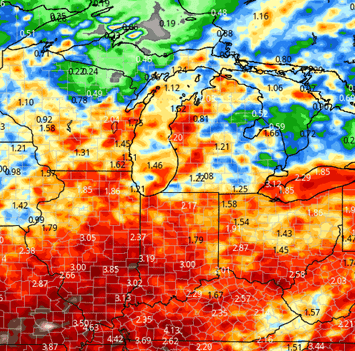
The initial move comes from the west and northwest and then we see the funneling up of moisture out of south and southwestern parts of the region later on in the period. In any case we are looking at combined precipitation from the Sunday time frame through the Tuesday time frame at anywhere from a tenth to one inch over about 80 to 90% of both Michigan and Indiana.
A second major area of cutoff low pressure will try to work out of the essential and southern plains early in the week and that will track across the Missouri valley Ohio Valley Tennessee Valley all the way through the second part of this upcoming week. What that should do is give us a better chance at precipitation for the Wednesday through a Saturday time frame, although I do think that we squeeze out a mostly dry day on Wednesday also we have to pay attention here to the fact that best precipitation over those three to four days will be areas of Illinois Indiana and Ohio.
Secondarily the moisture gets up into Michigan, so I’m looking at a combined second-half of the week precipitation pattern that gives another quarter to 3/4 of an inch in Indiana and Ohio. Then farther north and Michigan you’re probably seeing the best moisture pushed back into Friday and Saturday where we can see upwards of a tenth to half an inch with slightly higher totals on toward the end of the period.
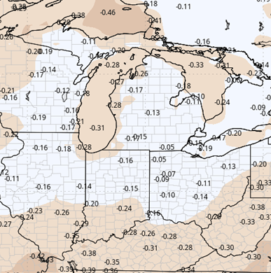
We finish out the nearby 10 day forecast window with a slightly drier pattern as we move into the 28th, 29th, and 30th. I think we put together at least two days of partly sunny and drier weather maybe a little bit cooler but not too bad. Then as we hit the late the 30th into October 1st we are watching a frontal boundary come together moving in from the West and northwest.
That front does not necessarily have a big batch of moisture with it but it is holding back some cooler air such that we get into those first few days of October and we’re likely going to be putting together a cooler pattern and one that can see some moisture get wrung out just due to an air mass change.
Extended Period:
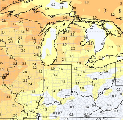
The extended 11 to 16 day forecast window will be putting together a unsettled but largely problem free pattern. Overall we’re seeing temperatures stay fairly close to normal for this time of year I won’t rule out some pop up scattered showers especially as we get closer to the 3rd 4th and 5th but outside of that the pattern looks relatively dry period going back to the West taking a look at the Great Plains and even the western corn belt you’re seeing a large scale upper level ridge trying to come in and take full control of the region in doing that it probably sets us up for a slightly drier setup as we move into that first full week of October.
Weeks 3 & 4:
Below normal precipitation in week 3, near normal for week 4. Temps well above normal through both weeks.
Week 3 Precipitation:
Week 3 Temperature:
Week 4 Precipitation:
Week 4 Temperature: