
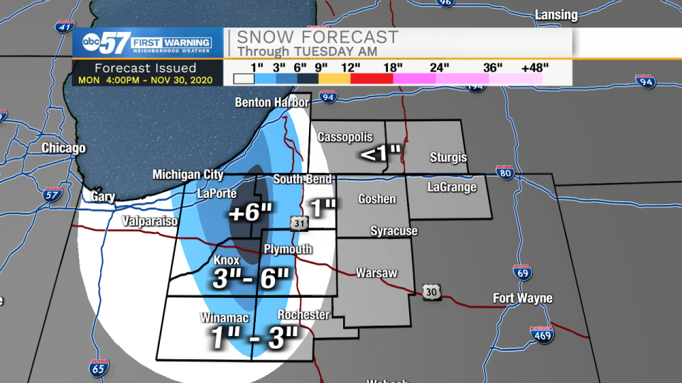
(Tom Coomes/ABC 57 Chief Meteorologist) Lake effect snow showers continue through Tuesday night. The worst travel will be Tuesday morning for areas between Michigan City and South Bend. The LaPorte / St. Joseph county line as well as parts of Berrien Co could see more than six inches of snow, in total. The real question is how much snow makes it into South Bend. It is possible most of South Bend-east to see little to no accumulation. Low visibility, blowing snow is the greatest threat to travel.
Lake effect snow showers last through Tuesday morning them taper off through the day. The snow will melt the rest of this week, with fair weather and milder temperatures, warming into the 40s. The weather pattern returns to a fairly quiet one, with little as far as winter weather through the middle of next week.
WINTER STORM WARNING REMAINS IN EFFECT UNTIL 9 AM EST /8 AM
CST/ TUESDAY...

* WHAT...Periodic bands of heavy lake effect snow expected with
  total snow accumulations of up to 8 inches within the heaviest
  bands. Winds gusting as high as 40 mph will cause blowing and
  drifting snow into Tuesday morning.

* WHERE...In Indiana, La Porte and Starke Counties. In Michigan,
  Berrien County.

* WHEN...Until 9 AM EST /8 AM CST/ Tuesday.

* IMPACTS...Travel will be very difficult. Heavy snow rates paired
  with strong wind gusts will significantly reduce visibility at
  times. Travel this evening through Tuesday morning will be
  hazardous.

* ADDITIONAL DETAILS...Visibility and road conditions will vary
  greatly over small distances. Snow accumulations will be
  extremely variable.
WINTER WEATHER ADVISORY REMAINS IN EFFECT UNTIL 9 AM EST
TUESDAY...

* WHAT...Snow expected. Total snow accumulations of 2 to 4
  inches.

* WHERE...St. Joseph IN and Marshall Counties.

* WHEN...Until 9 AM EST Tuesday.

* IMPACTS...Visibility and road conditions can vary greatly over
  small distances. Snow accumulations will be extremely variable.

* ADDITIONAL DETAILS...The lake effect snow band will move in and
  out of the western St. Joseph and Marshall counties through this
  evening. Overnight and into Tuesday, the band will spread
  further eastward through Marshall and St. Joseph counties.

PRECAUTIONARY/PREPAREDNESS ACTIONS...

Motorists should be alert for highly variable visibility and
roadway conditions.
Your ABC 57 First Warning Neighborhood Weather Center Forecast:
Monday Night: Lake effect snow and windy. Low 30.
Tuesday: Lake effect snow, mainly early. Breezy. High 35.
Wednesday: Mostly sunny. High 42.
Thursday: Partly cloudy. High 42