
An arctic cold front will bring a round of snow showers by Thursday afternoon, Jan. 24.
Lake effect snow showers linger through the night north of U.S. 6. Parts of northern LaPorte, St. Joseph and Elkhart Counties could see an inch of snow, but the heavier totals of 1-3” will be confined to Berrien and Cass Counties.
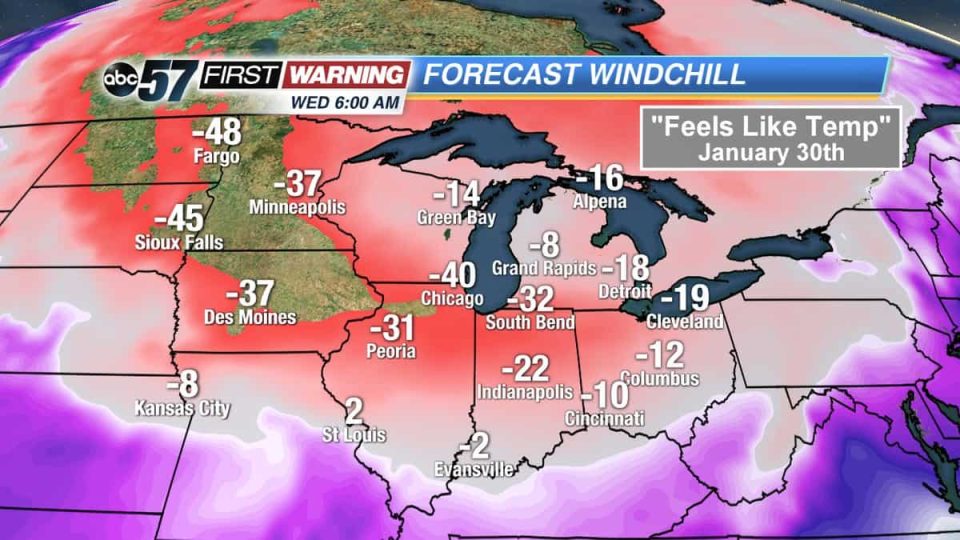
Temperatures will drop to 2° and only warm to 8° on Friday. The National Weather Service of Northern Indiana has issued a Wind Chill Advisory to start at 3 a.m. on Friday morning and last until 1 p.m. on Friday afternoon.
Another round of light snow showers is likely Friday night with lows again in the single digits.
WIND CHILL ADVISORY IN EFFECT FROM 3 AM EST /2 AM CST/
TO 1 PM EST /NOON CST/ FRIDAY

* WHAT...Very cold wind chills expected. Wind chills as low as
  20 below zero expected.

* WHERE...Portions of northern Indiana, southwest Michigan and
  northwest Ohio.

* WHEN...From 3 AM EST /2 AM CST/ to 1 PM EST /noon CST/ Friday.

* ADDITIONAL DETAILS...The cold wind chills could cause
  frostbite on exposed skin in as little as 30 minutes.

PRECAUTIONARY/PREPAREDNESS ACTIONS...

A Wind Chill Advisory means that cold air and the wind will
combine to create low wind chills. Frostbite and hypothermia can
occur if precautions are not taken. Make sure you wear a hat and
gloves.
Temps climb to near 20° and into the 20s this weekend and Monday with the best chance of snow coming Monday into Tuesday. That system bears watching as we could see enough warm air surge in to allow rain to mix in. If it stays all snow, accumulations are likely. The coldest air of the season and in several years arrives behind it for next week.
Your ABC 57 First Warning Neighborhood Weather Center Forecast:
Thursday: Mostly cloudy with a chance of snow showers later in the day. High of 25.
Thursday Night: Mostly cloudy with a chance of lake effect snow showers. Low of 2.
Friday: Morning snow showers possible under mostly cloudy skies. High of 8.
Saturday: Mostly cloudy skies. High of 19.