

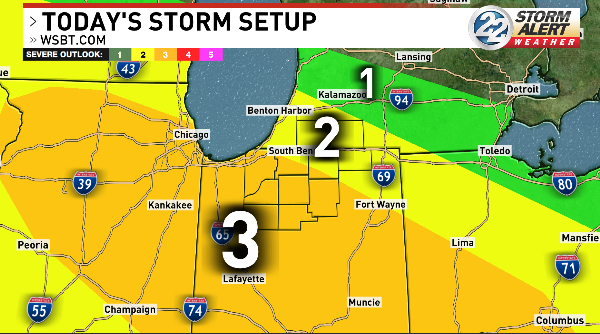
(WSBT Storm Alert Weather Team) Severe weather is expected once again in Michiana.
The Storm Prediction Center has placed a large amount of our area under a Level 3 risk for severe weather on Tuesday.
The day already starts off wet with rain and storms rolling through during the morning commute. Some have been severe with damaging winds and hail.
We will likely get a short break in the rain around mid-morning, but another round of strong storms will be fast on its heels.

Chances for storms will increase in the early afternoon. By around 2 p.m. widespread rain and storms are expected.
There is a chance the morning round of rain shortly before the afternoon storms could help lower the storm strength, however the afternoon storms will still have quite a bit of storm energy to work with thanks to the high humidity in our area.
Storms could be strong with damaging winds as the main threat, although all hazards are possible.

Heavy downpours are also a possibility with these storms. Some places could see well over an inch of rainfall today.
With recent heavy rains, this will increase the risk for localized flooding.
Rain will push out of our area as we approach the evening hours.
Tonight will be quiet and dry.
More rain chances are on the way Wednesday.
Rain and storms become possible once again Wednesday afternoon, though our risk for severe weather looks a lot lower than past days.
The Storm Prediction Center has placed part of our area under a Level 1 risk for severe weather Wednesday.
Any stronger storms Wednesday could contain damaging winds.
Rain chances will back off a bit toward the end of the week, but we still will see showers off and on through the weekend.
The heat and humidity will go down a bit toward the end of the week as well. Highs will be in the upper 70s Thursday and last through the weekend
