
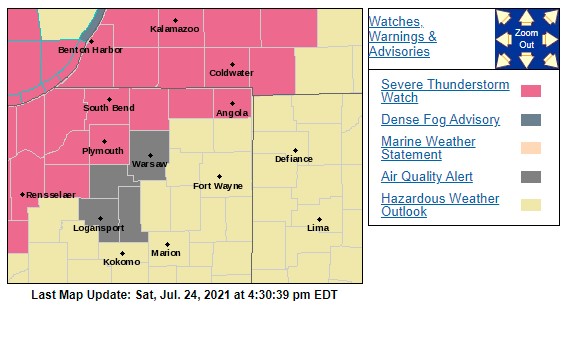
A Severe Thunderstorm Watch is in effect for the MNC listening area through 11 p.m. EDT on Saturday, July 24, as temperatures soar into the upper 80s this afternoon with heat indices in the mid 90s.
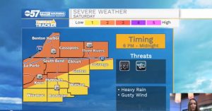
This evening a line of storms will move across Michiana. A few storms could be on the strong/severe side. The biggest threat is damaging gusty winds, although periods of heavy downpours could also be a concern. Flood risk looks low, as the storms move quickly. Most begin to wrap up by midnight. Sunday should stay dry and mostly sunny. It’ll be another hot one with heat indices in the low 90s. This week stays hot with some relief after showers Wednesday night into Thursday.
SEVERE THUNDERSTORM WATCH OUTLINE UPDATE FOR WS 391
NWS STORM PREDICTION CENTER NORMAN OK
330 PM CDT SAT JUL 24 2021

SEVERE THUNDERSTORM WATCH 391 IS IN EFFECT UNTIL 1000 PM CDT
FOR THE FOLLOWING LOCATIONS

INC007-039-073-087-089-091-099-111-127-131-141-149-151-250300-
/O.NEW.KWNS.SV.A.0391.210724T2030Z-210725T0300Z/

INDIANA COUNTIES INCLUDED ARE
BENTON               ELKHART             JASPER
LAGRANGE             LAKE                LA PORTE
MARSHALL             NEWTON              PORTER
PULASKI              ST. JOSEPH          STARKE
STEUBEN

IN MICHIGAN
BERRIEN
CASS
ST. JOSEPH
VAN BUREN
Your ABC 57 First Warning Neighborhood Weather Center Forecast:
Saturday: Partly sunny and hot. PM thunderstorms. High 88.
Saturday Night: Storms before midnight. Low 72.
Sunday: Mostly sunny. High 88.
Monday: Sunny. High 88.