
There is a heat advisory from 1 p.m. to 8 p.m. on Tuesday, Aug. 10, for northern and western Indiana. Strong to severe storms are also possible during that time and later in the evening.
“Those places will probably see heat index values between 100 and 105 degrees in the peak of the afternoon,” said Andrew White, meteorologist with the National Weather Service. “The big thing in your vehicles is to make sure, if you have pets or children with you, to always look before you lock. It is very dangerous to leave animals or children in cars on days like today where it’s this hot.”
It is also after 1 p.m. that White thinks storms will move through the state.
“The stronger storms will move in after 1 p.m. and that is going to continue through the evening and maybe the overnight hours. The part of the state that looks to be getting it the worst is the northwest portions of the state that had the bad weather Monday night. The main thing we’re concerned about is damaging winds, but as with any storm, we’re also concerned about heavy rain and lightning,” said White.
After today, the threat for severe weather diminishes, but showers and thunderstorms will likely stick around.
“We’re going to be in this pattern of afternoon and evening thunderstorms really for the rest of the week. The storms later in the week don’t look to be quite as strong like the ones we could be seeing today and tonight,” said White.
At this point, cooler and drier weather is expected to arrive this weekend.
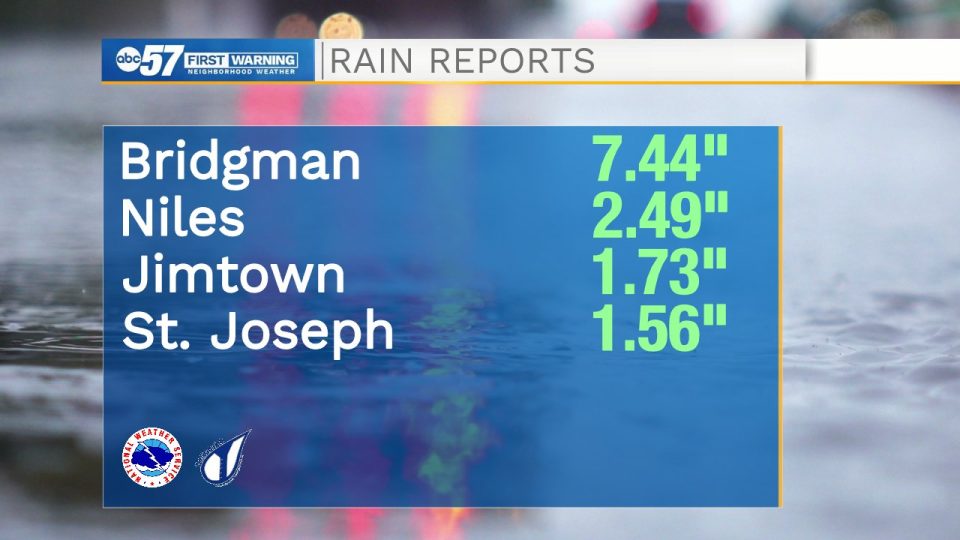
As far as storm totals from the overnight storm from early Tuesday morning:
VERY HEAVY RAIN fell overnight – over 7″ of rain in Bridgman!
How much rain have you seen in our neighborhood? Are you seeing any flooding? pic.twitter.com/aJ6CYqVPlT
— Emily Kennedy (@EmilyKennedyWX) August 10, 2021