
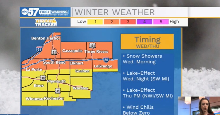
A Winter Weather Advisory is in effect for Berrien and Cass Counties in Michigan from 4 a.m. on Wednesday, Jan. 5 until 7 a.m. on Thursday, Jan. 6.
We’ll see a round of snow showers/flurries to start in the morning.
Temperatures start in the 30s, but gradually fall into the teens by the afternoon. Gusty winds tomorrow will make it feel cold through the day.
Wednesday afternoon will transition to lake effect snow in mainly our Michigan counties. Another round of lake effect is likely on Thursday, impacting our Michigan counties plus northern Indiana counties.
It will be cold both Thursday and Friday with highs at or below 20, then a rebound to temperatures in the 30s over the weekend.
WINTER WEATHER ADVISORY IN EFFECT FROM 4 AM WEDNESDAY TO 7 AM
EST THURSDAY FOR BERRIEN, CASS COUNTIES IN MICHIGAN.

* WHAT...Snow and blowing snow expected. Total snow accumulations
  of 2 to 5 inches, with locally higher amounts, especially across
  northern Berrien County. Winds gusting as high as 45 mph.

* WHERE...Berrien and Cass Counties.

* WHEN...From 4 AM Wednesday to 7 AM EST Thursday.

* IMPACTS...Plan on slippery road conditions. Patchy blowing snow
  could significantly reduce visibility. The hazardous conditions
  could impact the morning or evening commute. Gusty winds could
  bring down tree branches.

PRECAUTIONARY/PREPAREDNESS ACTIONS...

Slow down and use caution while traveling.
Your ABC 57 First Warning Neighborhood Weather Center Forecast:
Wednesday: Cloudy, windy, with snow showers possible. AM temperatures in 30s will become colder through the day.
Thursday: Scattered snow showers. Cold. High 20.
Thursday Night: A 40 percent chance of snow showers. Mostly cloudy, with a low around 8.
Friday: A 20 percent chance of snow showers in the morning, then partly sunny and cold, with a high near 16.
Friday Night: Mostly cloudy, with a low around 2.
Saturday: Mostly sunny, with a high near 34.
Sunday: A chance of rain and snow showers. Mostly cloudy, with a high near 37.