
Forecasters are warning of an increased risk of severe weather across the region on Wednesday, June 17, with the greatest threat expected during the evening hours.
The day is expected to begin with partly cloudy skies before rain develops around midday. Showers and thunderstorms are forecast during the afternoon, but the most significant threat for severe weather is expected between 7 p.m. and 11 p.m.
Meteorologists say all forms of severe weather are possible, including damaging wind gusts and tornadoes. Residents are encouraged to monitor forecasts throughout the day and have multiple ways to receive weather warnings.
High temperatures on Wednesday are expected to reach the mid-70s.
Conditions will improve somewhat on Thursday, although mostly cloudy skies and a few light rain showers remain possible. Highs will stay in the lower 70s.
Looking ahead to the weekend, Friday is expected to be mostly dry. Small chances for rain return on Saturday and Sunday.
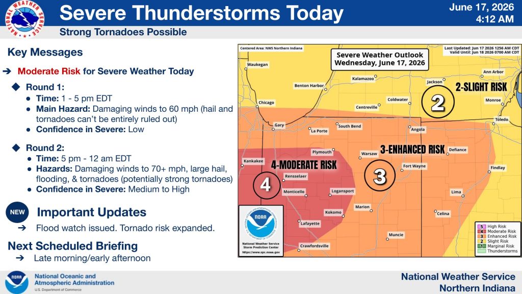 The National Weather Service has placed much of northern Indiana under an Enhanced Risk (Level 3 of 5) for severe weather, while areas west of Fort Wayne are under a Moderate Risk (Level 4 of 5), indicating widespread severe storms are possible. Officials say the tornado threat has expanded farther north and east compared to previous forecasts.
Forecasters are expecting two rounds of storms Wednesday. The first round is expected between 1 p.m. and 5 p.m., with damaging wind gusts up to 60 mph as the primary concern. While the risk for tornadoes and hail during the afternoon remains lower, they cannot be completely ruled out.
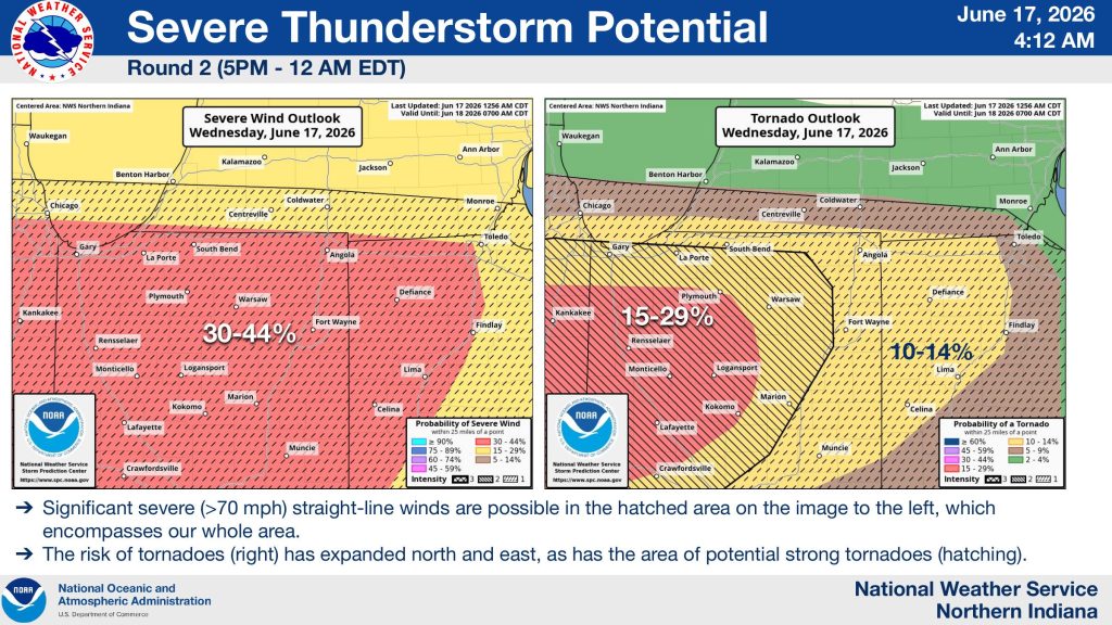 The second round, expected between 5 p.m. and midnight, poses the greatest threat. The National Weather Service says storms during this period could produce wind gusts exceeding 70 mph, large hail, flash flooding, and tornadoes, including the possibility of strong tornadoes. Confidence in severe weather during the evening and overnight hours is medium to high.
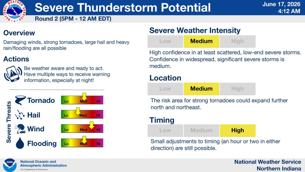
Meteorologists say there is high confidence that at least scattered severe storms will develop, with a medium confidence level that significant severe weather could become widespread across portions of the region. The timing of the evening storms may shift by an hour or two, but forecasters expect the threat to continue well after sunset.
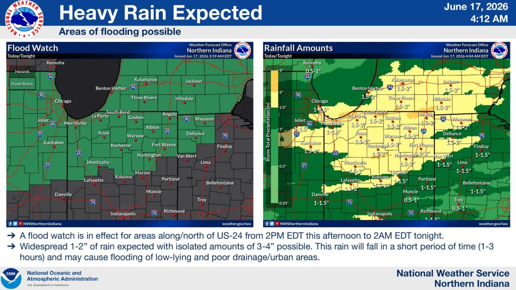
In addition to the severe weather threat, a Flood Watch has been issued for areas along and north of U.S. 24 from 2 p.m. Wednesday through 2 a.m. Thursday. Rainfall totals of 1 to 2 inches are expected across much of northern Indiana, with isolated amounts of 3 to 4 inches possible. The National Weather Service warns that the heavy rain could lead to flooding in low-lying areas, urban locations, and places with poor drainage.
 Residents are urged to closely monitor weather conditions throughout the day and ensure they have multiple ways to receive warnings, especially during the overnight hours when severe storms may strike after dark. NOAA Weather Radio, smartphone alerts, local media, and weather apps are all recommended methods for receiving life-saving warning information.
 WOWO News will continue to provide updates throughout the day as the severe weather threat develops.