
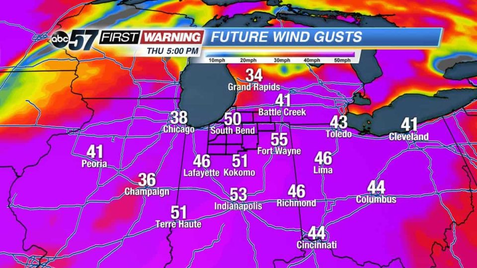
A strong spring storm will bring wind, rain and possible severe weather to Michiana on Thursday, March 14. A Wind Advisory is in effect for the region from 11 a.m. until 8 p.m. on Thursday. Gusts to 45 m.p,.h. are possible during that time.
WIND ADVISORY IN EFFECT FROM 11 AM EDT /10 AM CDT/ TO 8 PM EDT
/7 PM CDT/ THURSDAY...

The National Weather Service in Northern Indiana has issued a
Wind Advisory...which is in effect from 11 AM EDT /10 AM CDT/ to
8 PM EDT /7 PM CDT/ Thursday.

HAZARDOUS WEATHER...

 * Southwest winds of 25 to 30 mph with gusts to 45 mph can be
   expected from late Thursday morning into the early evening
   hours. These strong winds will not be associated with the
   expected thunderstorms on Thursday.

 * Isolated gusts to 50 mph will be possible.

IMPACTS...

 * Isolated tree and power line damage is possible.

 * Unsecured outdoor objects will be blown around.

PRECAUTIONARY/PREPAREDNESS ACTIONS...

A Wind Advisory means that sustained winds of 30 mph or gusts of
45 mph are expected. Winds this strong can make driving
difficult...especially for high profile vehicles. Use extra
caution.
A round of rain is likely in the morning. If sunshine appears after the rain, temperatures could make a run at 70 degrees, raising the severe threat.
The storms will be moving quickly, so early warning will be limited.
Temperatures drop and the wind gradually calms into Friday.
Thursday: Windy, gusts up to 50 mph, scattered showers and storms, high of 68.
Friday: Mostly cloudy, chance of mix/snow as temperatures fall from 42.
Saturday: Mostly cloudy, high of 36.
Sunday: Partly sunny, with a high near 40.
Monday: Mostly sunny, with a high near 42.
Tuesday: Mostly sunny, with a high near 43.
Wednesday: Mostly cloudy, with a high near 43.