
(Tyler Sebree/ABC 57) Our first major winter storm of the season begins early Monday, Nov. 11, and lasts through the early afternoon hours of Tuesday.
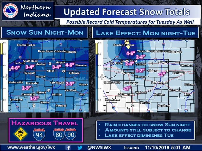
Berrien, Cass, La Porte, and St. Joseph Counties are under a Winter Storm Warning for 5-9” of snow with some easily seeing 8-12”. Everyone else is under a Winter Weather Advisory for a widespread 3-4” of snow with some seeing 5-8” closer to the lake effect bands.
Light showers will mix with and change to light snow late tonight into the pre-dawn hours of Monday. Light to occasionally moderate snow will fall everywhere Monday morning into Monday afternoon with lake effect snow then taking over by dinnertime. Areas who see the lake effect snow bands will see moderate to heavy snow with rates of 1-2” per hour possible. If you’re not in the lake effect zone, you are done with snow by late Monday afternoon.
Otherwise, it’s very cold with highs struggling to get to 30. It’ll be even colder Tuesday and Wednesday with highs in the 20s and lows in the single digits and teens.
A slight moderation in temperatures will occur by late in the week as highs get back to and above the freezing mark by Thursday. It’s possible we could see some light snow again late in the day Wednesday and Wednesday night, but that will likely be minor.
Monday: Steady system snow transitions to lake effect snow. Breezy. High of 30.
Tuesday: Mostly cloudy with lake effect snow showers. Frigid. High of 22.
Wednesday: Mostly cloudy with a slight chance of snow showers late in the day. High of 25.
URGENT - WINTER WEATHER MESSAGE
National Weather Service Northern Indiana
300 PM EST Sun Nov 10 2019

INZ003-004-110400-
/O.NEW.KIWX.WS.W.0003.191111T1000Z-191112T2200Z/
La Porte-St. Joseph IN-
Including the cities of Michigan City, La Porte, South Bend,
Mishawaka, New Carlisle, and Walkerton
300 PM EST Sun Nov 10 2019 /200 PM CST Sun Nov 10 2019/

...WINTER STORM WARNING IN EFFECT FROM 5 AM EST /4 AM CST/ MONDAY
TO 5 PM EST /4 PM CST/ TUESDAY...

* WHAT...Heavy snow expected. Total snow accumulations of 5 to 9
  inches are expected.

* WHERE...La Porte and St. Joseph IN Counties.

* WHEN...From 5 AM EST /4 AM CST/ Monday to 5 PM EST /4 PM CST/
  Tuesday.

* IMPACTS...Untreated roads will become snow covered and travel
  difficult. The hazardous conditions could impact the morning
  and evening commutes on Monday and Tuesday.

* ADDITIONAL DETAILS...Widespread light to moderate snow will
  develop late tonight and continue into Monday. This will then
  transition to periods of lake effect snow showers Monday night
  into Tuesday. One or more bands of moderate to locally heavy
  snow will be possible across portions of the warning area
  during this time.