
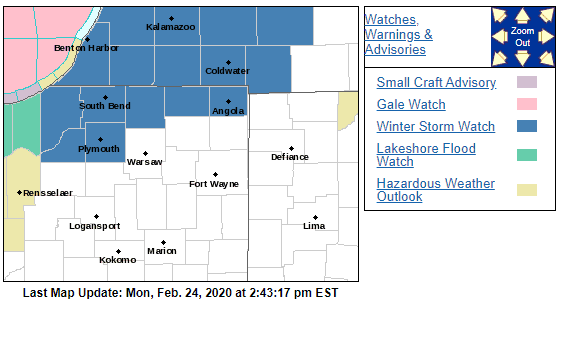
The National Weather Service of Northern Indiana has issued a Winter Storm Watch in effect Tuesday night, Feb. 25 – Wednesday night, Feb. 26 for St. Joseph, Elkhart, LaPorte, Marshall and Starke Counties in Indiana and Berrien, Cass and St. Joseph Counties in Michigan.
Snow is expected to begin late Tuesday night and continue through Wednesday evening.
...WINTER STORM WATCH IN EFFECT FROM TUESDAY EVENING THROUGH
WEDNESDAY NIGHT...

* WHAT...Heavy snow possible. Total snow accumulations in excess
  of 6 inches possible.

* WHERE...Portions of northern Indiana and southwest Michigan.

* WHEN...From Tuesday evening through Wednesday night.

* IMPACTS...Travel could be very difficult. The hazardous
  conditions could impact the Wednesday morning and evening
  commutes.


PRECAUTIONARY/PREPAREDNESS ACTIONS...

Monitor the latest forecasts for updates on this situation.
Tuesday
Rain before 9 a.m., then rain and snow between 9 a.m. and 10 a.m., then rain after 10 a.m. High near 39. Northeast wind around 15 mph, with gusts as high as 20 mph. Chance of precipitation is 100%. Little or no snow accumulation expected.
Tuesday Night
Rain and snow, becoming all snow after 11 p.m. Low around 30. Northeast wind 10 to 15 mph. Chance of precipitation is 80%. New snow accumulation of 1 to 2 inches possible.
Wednesday
Snow. High near 32. North wind 10 to 15 mph, with gusts as high as 20 mph. Chance of precipitation is 90%. New snow accumulation of 2 to 4 inches possible.
Thursday
Cloudy, with a high near 24.
Friday
Mostly cloudy, with a high near 25.
Saturday
Mostly cloudy, with a high near 29.
Sunday
Mostly sunny, with a high near 35.