
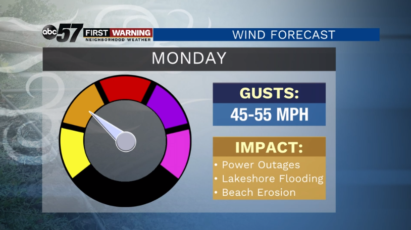
(David Caulfield/ABC 57 Meteorologist) While showers are possible on Monday morning, April 13, strong winds are the main headline grabber. Wind gusts of 45-55 mph are possible across Michiana on Monday, so be sure outside objects are secure or brought inside. The wind and weather pattern, in general, will be calmer on Tuesday, but temperatures will retreat back into the lower 40s again. Highs will stay in the 40s on Wednesday, Thursday, and Friday as well. Showers look likely on Friday before milder air returns for the weekend.
...WIND ADVISORY REMAINS IN EFFECT FROM 5 AM EDT /4 AM CDT/ TO
8 PM EDT /7 PM CDT/ MONDAY...

* WHAT...West winds 25 to 35 mph with gusts up to 50 mph
  expected. A brief period of gusts 50 to 55 mph is possible
  Monday morning.

* WHERE...Portions of northern Indiana, southwest Michigan and
  northwest Ohio.

* WHEN...From 5 AM EDT to 8 PM EDT Monday.

* IMPACTS...Gusty winds could blow around unsecured objects.
  Tree limbs could be blown down and a few power outages may
  result.

PRECAUTIONARY/PREPAREDNESS ACTIONS...

Use extra caution when driving, especially if operating a high
profile vehicle. Secure outdoor objects.
Your ABC 57 First Warning Neighborhood Weather Center Forecast:
Monday: Showers early. Windy and mostly cloudy. High 42.
Tuesday: Partly sunny. High 42.
Wednesday: Partly sunny and cool. High 41.