
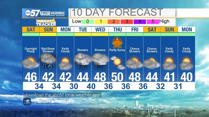
(Maci Tetrick/ABC 57 Meteorologist) The better day to head outside this weekend is Saturday. Skies are mostly cloudy, but it should stay dry.
Early Saturday morning, temperatures are in the 30s. We’ll warm to temperatures in the mid 40s by afternoon. Showers start late tonight after 10 p.m. Overnight, temperatures fall to a low around 34. This means precipitation could turn from rain showers to a wintry mix, and later it could be primarily snowflakes. How quickly temperatures fall and when we see the rain turn into snow will determine if snow accumulates.
There could be up to half an inch of snow, especially on grassy areas. Accumulation and icing on roadways shouldn’t be much of an issue because of our recent warm temperatures. Sunday afternoon precipitation continues to fall but turns back to rain as temperatures warm to the low 40s. This should help with melting any of the morning’s snow/ice. Rain wraps up by Sunday evening.
Monday is a dry start to the work week. More rain is expected Tuesday and Wednesday, but the forecast improves for Thanksgiving. It should be a mostly sunny Turkey Day with temperatures around 50 degrees.
Your ABC 57 First Warning Neighborhood Weather Center Forecast:
Saturday: Mostly cloudy. High 46.
Saturday night: Rain showers early, turning to rain/snow mix late. Low 34.
Sunday: Rain/snow showers early, turning to rain showers by afternoon. High 42.
Monday: Partly cloudy. High 42.