
A Winter Weather Advisory is in effect for most of the 95.3 MNC listening area from 1 a.m. until 1 p.m. on Sunday, Jan. 23.
Our eye is on the next round of accumulating snow that arrives after midnight.
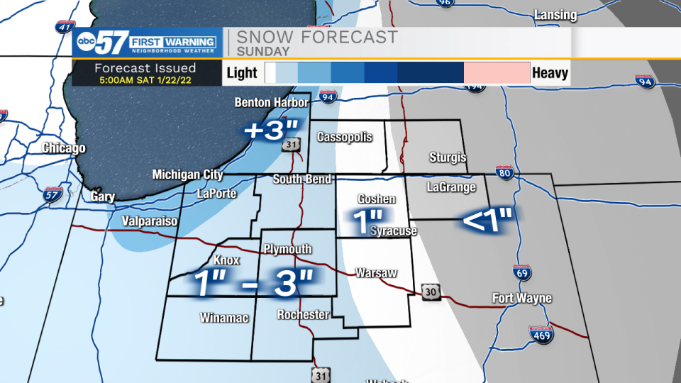
A cold front will swing through the area bringing snow showers through tomorrow morning, and then lake effect that will linger into Sunday afternoon. We could see some minor accumulations throughout the area.
Another round of snow will arrive Monday. This round could bring a few inches of snow accumulation to portions of Michiana.
After that clears, lake effect will linger into the middle of next week. Along with the lake effect, temperatures will also fall putting lows in the single digits, and highs in the teens to lower 20s.
St. Joseph-Elkhart-Noble-De Kalb-Starke-Pulaski-Marshall-Fulton-
Kosciusko-Whitley-Allen-White-Cass-Miami-Wabash-Huntington-Wells-
Adams-Grant-Blackford-Jay-Berrien-Defiance-Paulding-Putnam-
Van Wert-
Including the cities of South Bend, Mishawaka, New Carlisle,
Walkerton, Elkhart, Goshen, Nappanee, Kendallville, Ligonier,
Albion, Auburn, Garrett, Knox, North Judson, Bass Lake, Winamac,
Francesville, Medaryville, Plymouth, Bremen, Culver, Rochester,
Akron, Warsaw, Winona Lake, Syracuse, Mentone, Columbia City,
Tri-Lakes, South Whitley, Fort Wayne, New Haven, Monticello,
Monon, Brookston, Logansport, Royal Center, Peru, Grissom AFB,
Mexico, Wabash, North Manchester, Huntington, Roanoke, Bluffton,
Ossian, Decatur, Berne, Marion, Gas City, Upland, Hartford City,
Montpelier, Portland, Dunkirk, Niles, Benton Harbor, St. Joseph,
Fair Plain, Benton Heights, Buchanan, Paw Paw Lake, Defiance,
Sherwood, Hicksville, Paulding, Antwerp, Payne, Ottawa, Leipsic,
Columbus Grove, Continental, Pandora, Van Wert, Ohio City, Lima,
and Spencerville
253 PM EST Sat Jan 22 2022 /153 PM CST Sat Jan 22 2022/

...WINTER WEATHER ADVISORY IN EFFECT FROM 1 AM EST /MIDNIGHT CST/
TO 1 PM EST /NOON CST/ SUNDAY...

* WHAT...Snow expected. Total snow accumulations of 2 to 5
  inches.

* WHERE...Portions of northern Indiana, southwest Michigan and
  northwest Ohio.

* WHEN...From 1 AM EST /midnight CST/ to 1 PM EST /noon CST/
  Sunday.

* IMPACTS...Plan on slippery road conditions. Most untreated or
  unplowed roads will likely become snow covered and slippery.
  Travel over most areas Sunday is likely to be impacted.

* ADDITIONAL DETAILS...More snow is expected Monday that is likely
  to hamper travel and impact both the morning and evening
  commutes. The additional snowfall is likely to prompt new winter
  weather headlines.

PRECAUTIONARY/PREPAREDNESS ACTIONS...

Slow down and use caution while traveling. Travel could be very
difficult due to snow covered roads and rapidly changing
visibilities from both the falling snow and patchy blowing snow.
Monitor the latest forecasts for updates on this situation. If
traveling, be sure to carry blankets, water, some extra food, and
a flashlight.
Your ABC 57 First Warning Neighborhood Weather Center Forecast:
Saturday: Flurries. High 29.
Saturday Night: Scattered snow showers. Low 19.
Sunday: Snow showers. High 24.
Monday: Snow showers. High 32.