
A Winter Weather Advisory is in effect for most of the 95.3 MNC listening area.
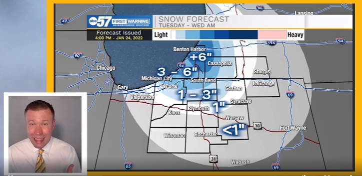
Lake effect snow begins Monday, Jan. 24, after 6 p.m., and will linger into late Tuesday morning. LaPorte and St. Joe Counties in Indiana, in addition to Berrien and Cass Counties in Michigan, could pick up an additional 2-4” of lake effect snow by Tuesday.
As far as temperatures go – today may be the warmest day of the week. Bitter cold arrives Tuesday overnight with a low of 4 degrees. Wednesday’s high is just 14 degrees, and Wednesday night drops to 2 degrees. It’s still cold to end the week, but not as frigid.
URGENT - WINTER WEATHER MESSAGE
National Weather Service Northern Indiana
444 AM EST Mon Jan 24 2022

INZ003-004-MIZ077-241900-
/O.CON.KIWX.WW.Y.0007.220124T1100Z-220125T1800Z/
La Porte-St. Joseph-Berrien-
Including the cities of Michigan City, La Porte, South Bend,
Mishawaka, New Carlisle, Walkerton, Niles, Benton Harbor,
St. Joseph, Fair Plain, Benton Heights, Buchanan,
and Paw Paw Lake
444 AM EST Mon Jan 24 2022 /344 AM CST Mon Jan 24 2022/

...WINTER WEATHER ADVISORY REMAINS IN EFFECT UNTIL 1 PM EST /NOON
CST/ TUESDAY...

* WHAT...Snow expected. Total snow accumulations of 4 to 8 inches
  with localized higher amounts where lake banding persists.
  Patchy blowing and drifting snow will be possible in rural
  areas.

* WHERE...In Indiana, La Porte and St. Joseph Counties. In
  Michigan, Berrien County.

* WHEN...From 6 AM EST /5 AM CST/ Monday to 1 PM EST /noon CST/
  Tuesday.

* IMPACTS...Travel could be very difficult at times. The hazardous
  conditions will impact the morning and evening commutes.

PRECAUTIONARY/PREPAREDNESS ACTIONS...

Slow down and use caution while traveling.
Your ABC 57 First Warning Neighborhood Weather Center Forecast:
Tuesday: Isolated lake effect snow. High 22.
Tuesday Night: Chance of snow showers. Mostly cloudy, with a low around 4.
Wednesday: Turning partly sunny and cold, with a high near 14.
Wednesday Night: Partly cloudy, with a low around 2.
Thursday: A slight chance for snow. Mostly cloudy, with a high near 28.
Friday: A slight chance for snow. Partly sunny, with a high near 26.
Saturday: Mostly sunny, with a high near 24.
1 comment
I’m sure glad we have all this gullible warming the left keeps babbling about. Think how many more feet of snow we’d have without it!