
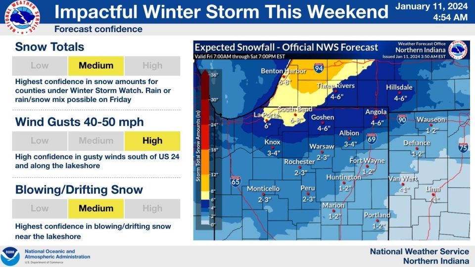
A winter storm will impact the area starting Friday and last through Saturday, with lingering lake-effect snow through Sunday. The storm will bring more rain than snow before 6:00 PM Friday then as temperatures fall snow is more likely to accumulate and be impactful through Saturday morning. The worst winter weather will be from midnight, early Saturday through noon. Temperatures continue to fall through Saturday, temperatures will be in the single digits or colder through Tuesday of next week.
TIMING:
Wet Snow Early Friday
Rain/Snow until 6:00 PM Friday
Changing to all snow after 6:00 PM Friday
Heavy snow Saturday morning
Most 3″-6″ through Saturday 6:00 PM
Windy – Gusts +40 mph Saturday morning
Lake effect snow Saturday PM to Sunday PM
Bitter cold starts Saturday night.
...WINTER STORM WARNING IN EFFECT FROM 10 AM EST /9 AM CST/
FRIDAY TO 7 PM EST /6 PM CST/ SATURDAY...

* WHAT...Heavy snow and blowing snow expected. Total snow
  accumulations of 4 to 8 inches. Winds gusting as high as 50 mph
  late Friday night into Saturday.

* WHERE...Portions of northern Indiana and southwest Michigan.

* WHEN...From 10 AM EST /9 AM CST/ Friday to 7 PM EST /6 PM CST/
  Saturday.

* IMPACTS...Travel could be very difficult. Widespread blowing
  snow could significantly reduce visibility. The hazardous
  conditions could impact the Friday evening commute. Gusty winds
  could bring down tree branches.

* ADDITIONAL DETAILS...The worst travel conditions from snow and
  blowing snow will be late Friday afternoon through Saturday
  morning. Rain will likely mix with snow for most of Friday which
  may limit impacts and accumulations during the day.

PRECAUTIONARY/PREPAREDNESS ACTIONS...

If you must travel, keep an extra flashlight, food, and water in
your vehicle in case of an emergency.
Friday: Rain/snow, windy. High 38.
Saturday: Snowy. windy, falling temperatures from 26.
Sunday: Bitter Cold, Lake effect snow. High 8. Overnight low near or at 0 with below zero wind chills.
Monday: A high of 6.