
The Flash Flood Warning issued for the 95.3 MNC listening area continued until 4:15 a.m. on Tuesday, Aug. 16.
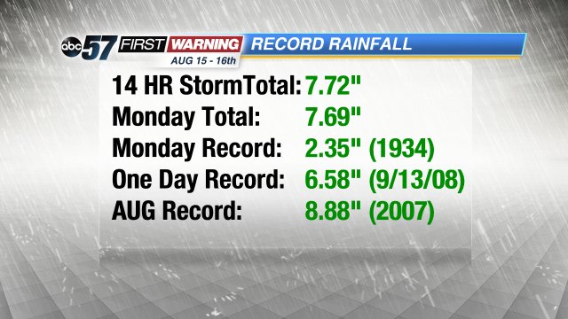
At 2:57 a.m. surface observations and Doppler Radar estimated that a total of 4 to 8 inches of rain had fallen across the warning area since Monday afternoon, according to the National Weather Service.
The heaviest rainfall amounts were reported from eastern Starke County through much of St. Joseph County, extending northeast into extreme southeast Berrien County and southwest Cass County in southwest Michigan, the National Weather Service reported.
Additional rainfall amounts should total less than a quarter of an inch through daybreak, Tuesday, the National Weather Service stated.
Extensive flooding and flash flooding were reported in the south bend vicinity with numerous reports of vehicle rescues, submerged vehicles and closed roads.
Areal flooding is expected to continue through the morning hours.
Area police are urging motorists to not drive through flooded roadways.
More than 2,300 Indiana Michigan Power customers were without power as of 3:30 a.m. due to the storm.
| Indiana Michigan power outages last updated: 03:28 AM ET 08-16-2016 | |||
| County | Customers Without Power |
Total Customers | Percentage |
|---|---|---|---|
| Elkhart Co., IN | 317 | 48,589 | 0.7 |
| St. Joseph Co., IN | 786 | 92,696 | 0.8 |
| Berrien Co., MI | 341 | 79,802 | 0.4 |
| Cass Co., MI | 789 | 13,332 | 5.9 |
| Van Buren Co., MI | 307 | 18,030 | 1.7 |
| IN totals: | 1,103 | 460,941 | 0.2 |
| MI totals: | 1,437 | 128,516 | 1.1 |
| Total Outages | 2,540 | 589,457 | 0.4 |
Two SB residents using a canoe to get around. @ABC57News pic.twitter.com/3Xzx4t6t7L
— Evan Sery (@EvanSeryABC57) August 16, 2016
Main Street in Mishawaka as of 2am. @ABC57News pic.twitter.com/jkNuoVx4Jk
— Emily Kinzer (@EKinzer_ABC57) August 16, 2016
Lake at Indian Lakes flooded- some areas very close to doors of first floor apts! #Mishawaka @TomCoomes @ABC57News pic.twitter.com/HsvDdN8tiO
— Brian Dorman (@BDormanTV) August 16, 2016
BREAKING: people have resorted to a canoe for transportation. @ABC57News @TomCoomes @BDormanTV @ColleenABC57 pic.twitter.com/F6VqWYn8Vv
— Evan Sery (@EvanSeryABC57) August 16, 2016
This is the street where a fridge was floating earlier. @ABC57News pic.twitter.com/A4G0atDuRW
— Evan Sery (@EvanSeryABC57) August 16, 2016
Flood watches/warnings effective in our area. Avoid flooded roadways & check local news before the morning commute. pic.twitter.com/8yzqdjAPWj
— Pete Buttigieg (@PeteButtigieg) August 16, 2016