
Another burst of snow looks likely on Saturday night, Jan. 26, with more lake effect for the first half of Sunday.
Only minor accumulations of 1”-3” are expected in the laek-effect zones and along and south of U.S. 30, with smaller amounts for everyone else. Temps this weekend continue to look cold with highs in the mid to upper teens.
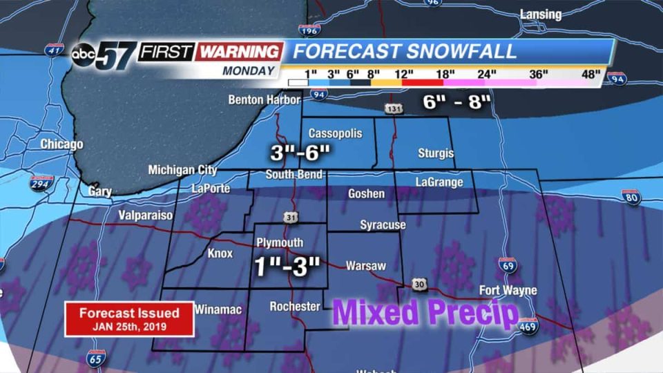
The focus continues to be on Monday’s storm.
Totals around the toll road area stay around 3”-6” with 6”-8” for the northern edge of Michigan counties. South of the toll road could be tricky as a wintry mix could cut amounts down even more.
After the snow, Michiana could experience potentially record-breaking cold.
Highs on Wednesday will struggle to hit -5.
Saturday night:
Light snow will overspread most of the area tonight. Less than an
inch of snow accumulation is expected, but slick roads are possible.

Sunday through Friday:
Heavy snow is possible Monday followed by bitterly cold temperatures
through the middle of this upcoming week. Strong winds combined with
subzero temperatures will cause wind chills below -25 from late
Tuesday into early Thursday. Significant disruptions in travel and
commerce are likely from Monday into Thursday.
Your ABC 57 First Warning Neighborhood Weather Center Forecast:
Saturday: Partly sunny to mostly cloudy with L.E. snow showers slowly fading. High of 16.
Saturday Night: Mostly cloudy with another burst of snow possible. Low of 10.
Sunday: Mostly cloudy with a chance L.E. snow showers, then partly sunny late. High of 16.
Monday: Cloudy with snow likely. Highs near 30.