
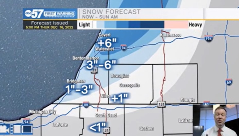
For most this is a cold weekend with a few snow showers. If you live or plan to travel towards northern Berrien County it will be very snowy. Travel along the I-196 corridor from Benton Harbor to Grand Rapids will be difficult with persistent lake effect snow. That area could get more than six inches by Sunday morning. The weather through next Wednesday is cold and mostly cloudy. Thursday-Friday before Christmas has consistently shown a snow storm plus lake effect combo, that lake effect could continue into Christmas Eve. There are still some IFs, but it is the highlighted period for greatest travel disruption.
URGENT - WINTER WEATHER MESSAGE
National Weather Service Northern Indiana
920 PM EST Fri Dec 16 2022

Northern Berrien-
Including the cities of Benton Harbor,
St. Joseph and Paw Paw Lake

WINTER WEATHER ADVISORY REMAINS IN EFFECT UNTIL 1 AM EST
SUNDAY

* WHAT...Lake effect snow. Total snow accumulations of 3 to 6
  inches.
* WHERE...Northern Berrien County.
* WHEN...Until 1 AM EST Sunday.
* IMPACTS...Travel could be very difficult. The hazardous
  conditions could impact the evening commute.

PRECAUTIONARY/PREPAREDNESS ACTIONS...
Slow down and use caution while traveling.
Your ABC 57 First Warning Neighborhood Weather Center Forecast:
Saturday: Cloudy with a few snow showers possible. High 30.
Sunday: Mostly cloudy. High 28.
Monday: Mostly cloudy. High 32