
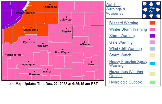
A Blizzard Warning for St. Joseph, Elkhart, LaPorte, Berrien, Cass and St. Joseph County in Michigan remains in effect until 1 p.m. on Saturday, Dec. 24. The rest of the 95.3 MNC listening area is under a Winter Storm Warning.
The bomb cyclone, as it’s being called, promises 9″ to 12″ or more of snow, gusty winds, and a dramatic drop in temperatures. These conditions last into the holiday weekend.
The heaviest snow starts around the same time as the Thursday evening drive home, and it will begin to accumulate quickly. You are advised to try to avoid traveling Thursday evening, overnight, and Friday.
Wind picks up this evening, with some wind gusts up to 30 m.p.h. by tonight.
The system snow continues overnight. Most system snow wraps up by Friday, however, lake effect snow will continue to impact the northern half of Michiana through Saturday.
Wind gusts on Friday up to 50 m.p.h. are possible. This will cause blizzard-like conditions, with blowing and drifting snow causing whiteout conditions on roads.
Wind chills tomorrow are dangerous: dropping at times to 20 to 25 below zero.
It’s still windy Saturday with wind gusts 35 mph. Wind chills stay below zero through the weekend.
Snow should finally come to an end by Christmas Day.
URGENT - WINTER WEATHER MESSAGE
National Weather Service Northern Indiana

BLIZZARD WARNING REMAINS IN EFFECT UNTIL 1 PM EST /NOON CST/
SATURDAY...

* WHAT...Blizzard conditions expected. Total snow accumulations
  in excess of a foot for many areas in Berrien and Cass
  counties in Michigan. Total snow accumulations of 6 to 12
  inches expected elsewhere. Winds gusting as high as 50 mph.

* WHERE...Portions of northern Indiana and southwest Michigan.

* WHEN...From 4 PM EST /3 PM CST/ this afternoon to 1 PM EST /noon
  CST/ Saturday.

* IMPACTS...Travel will be very difficult. Widespread blowing
  and drifting snow will significantly reduce visibility. The
  hazardous conditions will impact holiday travel. Gusty winds
  could bring down tree branches and cause power outages. The
  dangerously cold wind chills between 15 and 30 degrees below
  zero will cause frostbite on exposed skin in as little as 10
  minutes.
Your ABC 57 First Warning Neighborhood Weather Center Forecast:
Thursday Night: Snowy. Falling temperatures. Wind gusts up to 40 mph. Low 2.
Friday: Heavy snow ending. Wind gusts 50 mph. Blowing/drifting snow. Cold. High 6.
Saturday: Lake effect snow. Breezy and cold. High 10.
Christmas Day: Mostly cloudy and cold. High 10.