
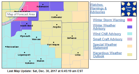
A Winter Storm Warning has been issued for Berrien, Van Buren and Allegan Counties. It’s in effect Saturday night through early Monday morning. Snowfall is expected in the 6 to 9 inch range. Some localized areas could get as much as 11 inches of snow.
A Winter Storm Warning for heavy lake effect snow means
significant amounts of lake effect snow are forecast that will
make travel very hazardous or impossible. If you must travel,
keep an extra flashlight, food, and water in your vehicle in case
of an emergency.
A Winter Weather Advisory has been issued for St. Joseph, LaPorte and Cass Counties. It’s in effect Saturday night through early Monday morning. Snowfall is expected in the 2 to 4 inch range, through some areas could receive higher amounts.
WHAT...Lake effect snow expected. Total snow accumulations of 2 to 4 inches, with
localized higher amounts. Plan on slippery road conditions.
Be prepared for reduced visibilities at times.
A Wind Chill Advisory has been issued for Marshall, Kosciusko, Starke and Pulaski Counties. It’s in effect Saturday night through early Sunday morning. Near zero air temperatures and wind will bring sub-zero wind chills to the region during this time.
Very cold wind chills expected, ranging from around 15 below zero to
20 below zero. Bitterly cold temperatures and wind chill
indices are likely to prompt additional advisories and
possible warning the next several nights.
Your ABC 57 First Warning Neighborhood Weather Center Forecast
(Meteorologist Alex Countee) – System snow will change over to lake effect this morning and continue for most in NW Michiana for the entire weekend. Totals from today and tonight will approach 6-8” around Berrien Co. with isolated spots reporting higher amounts. Sunday and Sunday night could see an additional 3-6+” in the lake effect zone, meaning that 12+” is still possible in Berrien Co. by Monday morning, which is why they are under a Winter Storm Warning from 8 PM tonight to midnight Sunday night.
Along with the snow, bitter cold temps are in store for the new year. Many of us could easily dip below zero by the morning of New Year’s Day. Highs Monday and Tuesday stay in the single digits but a “warm-up” could move by this time next week, as highs climb into the low 20s by the end of next weekend!
Saturday: Mostly cloudy with lake effect snow, high of 14.
Sat. Night: Mostly cloudy with lake effect snow. Low of 3.
Sunday: Lake effect snow, high of 10.
New Year’s Day: Mostly cloudy with a chance of L.E. snow, highs near 7.
With new snow cover, clearing skies and a reinforcing shot of arctic air, temperatures will drop to below zero overnight Sunday, Monday and pic.twitter.com/zYBqpFVzzE
— NWS Northern Indiana (@NWSIWX) December 30, 2017