
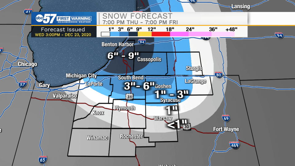
(Tom Coomes/ABC 57 Chief Meteorologist) A White Christmas is likely for most of the area as the lake effect snow machine ramps-up early Friday morning. Much of Thursday is cold and quiet, then snow showers gradually ‘turn-on’ Thursday evening, as temps fall into the teens and the wind backs to the northwest. This event has a short but potent window for snowfall, with most snow falling between 3 a.m. and 9 a.m. Christmas morning, when conditions are most favorable. The worst travel will be before 10 a.m., Friday, especially close to Lake Michigan. Christmas Day is cold, struggling to break 20 but temperatures rise into the 40s by Sunday.
Including the cities of Michigan City, La Porte, South Bend,
Mishawaka, New Carlisle, and Walkerton

WINTER STORM WATCH REMAINS IN EFFECT FROM THURSDAY EVENING
THROUGH FRIDAY AFTERNOON...

* WHAT...Heavy snow possible. Total snow accumulations of 4 to 8
  inches north of US20 and 2 to 4 inches south of US20 possible.

* WHERE...La Porte and St. Joseph IN Counties.

* WHEN...From Thursday evening through Friday afternoon.

* IMPACTS...Travel could become difficult overnight Thursday.
  The hazardous conditions will impact travel Christmas Day.

* ADDITIONAL DETAILS...The heaviest snow is expected late
  Thursday night and Friday morning.

PRECAUTIONARY/PREPAREDNESS ACTIONS...

Monitor the latest forecasts for updates on this situation.
Including the cities of Elkhart, Goshen, Nappanee, Sturgis,
Three Rivers, White Pigeon, and Mendon

WINTER WEATHER ADVISORY REMAINS IN EFFECT FROM 7 PM THURSDAY
TO 4 PM EST FRIDAY...

* WHAT...Occasional moderate snow and poor visibility due to
  snow and wind. Snow accumulations of 2 to 4 inches.

* WHERE...In Indiana, Elkhart County. In Michigan, St. Joseph MI
  County.

* WHEN...From 7 PM Thursday to 4 PM EST Friday.

* IMPACTS...Plan on slippery road conditions. The hazardous
  conditions will impact travel on Christmas Day.

* ADDITIONAL DETAILS...The heaviest snow is expected late
  Thursday night and Friday morning.

PRECAUTIONARY/PREPAREDNESS ACTIONS...

Slow down and use caution while traveling and be alert for highly
variable visibility and roadway conditions.