
A Winter Storm Warning is in effect for most of our southwestern Michigan counties until 4 p.m. on Friday, Jan. 7.
A Winter Weather Advisory is in effect for St. Joseph and Elkhart Counties until 10 a.m. on Friday, Jan. 7.
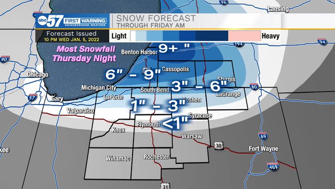
Snow will wrap up in the early afternoon Friday, and by the time it all wraps up, some (in southwest Michigan) could be dealing with a foot of snow. Highs won’t make it out of the teens during the day on Friday. Temperatures fall into the single digits Friday night, but quickly bounce back into the 30s by Saturday. A quick round of rain and snow moves through Saturday night, but at this point, this round of wintry mix looks more like an inconvenience than anything else. A little more lake-effect is possible Sunday night into Monday, as temperatures once again get cold to start the work week next week.
Including the cities of Niles, Benton Harbor, St. Joseph,
Fair Plain, Benton Heights, Buchanan, Paw Paw Lake, Dowagiac,
Cassopolis, Edwardsburg, and Marcellus
330 AM EST Fri Jan 7 2022

...WINTER STORM WARNING NOW IN EFFECT UNTIL 4 PM EST THIS
AFTERNOON...

* WHAT...Heavy lake effect snow and blowing snow. Additional snow
  accumulations of 3 to 7 inches.

* WHERE...Cass and Berrien Counties.

* WHEN...Until 4 PM EST this afternoon.

* IMPACTS...Travel will be very difficult in the northern sections
  of Berrien and Cass Counties. The hazardous conditions will
  significantly impact the morning commute. Stay home if you can.

* ADDITIONAL DETAILS...The strong lake effect snow band will
  continue to weaken and drift northeast through the morning.
  However...light snow will continue through much of the day with
  winds from the west at 10 to 20 mph.

PRECAUTIONARY/PREPAREDNESS ACTIONS...

If you must travel, keep an extra flashlight, food, and water in
your vehicle in case of an emergency.
YOUR ABC 57 FIRST WARNING NEIGHBORHOOD WEATHER CENTER FORECAST:
Friday: Snow showers in the morning, then decreasing clouds and cold. High 18.
Friday Night: A low of 6.
Saturday: Mostly sunny. High 35. Wintry mix moves in at night.
Sunday: Rain/snow in the morning, then becoming windy and colder. Morning high of 33 decreasing to 20 in the afternoon.
Monday: A chance of snow in the morning. Mostly cloudy and cold otherwise, with a high near 18.