
The holiday winter storm arrives on Michiana’s doorstep on Thursday. We’ll start out Thursday with a mixture of rain and snow. Some freezing rain is possible ,at times. Travel should be possible before 6 p.m. on Thursday. After that, a flash freeze is possible, which could make roads icy and dangerous. Precipitation will change over to all snow on Thursday night. Most of the area will experience near-blizzard conditions on Friday, with heavy snow and winds gusting over 40 m.p.h., making travel dangerous, if not impossible at points.
Most of the area should expect around 8 inches of snow by Friday night, with higher amounts expected closer to Lake Michigan. Along with all of this, feels-like temperatures could dip below -25 on Friday night. Lake effect snow will tack on several more inches of accumulation in the snow belts on Saturday. Even away from Lake Michigan, blowing and drifting snow could still be a concern, especially for the first part of Saturday. Snow should wrap up on Christmas morning. Highs on Christmas might not make it into the double digits.
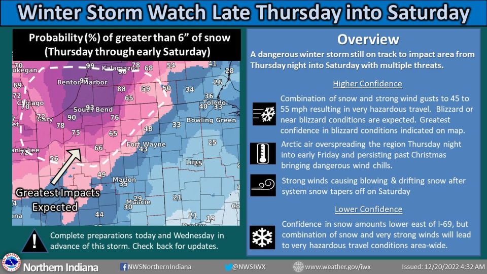
National Weather Service Northern Indiana

WINTER STORM WATCH REMAINS IN EFFECT FROM THURSDAY EVENING
THROUGH SATURDAY MORNING...

* WHAT...Blizzard conditions possible. A wintry mix Thursday
  transitions to all snow by Thursday evening. Snow will be
  moderate to heavy at times Thursday night into Friday before
  transitioning to lake effect snow through Saturday. Storm total
  snow amounts will be quite varied, exceeding well over one foot
  near Lake Michigan to a few inches in northwest Ohio. West
  winds could gust as high as 55 mph, and will cause significant
  blowing and drifting snow.

* WHERE...Portions of northern Indiana, southwest Michigan and
  northwest Ohio.

* WHEN...From Thursday evening through Saturday morning.

* IMPACTS...Falling or blowing snow may result in white out
  conditions with zero visibility at times, making travel
  extremely difficult, if not impossible. Strong winds may bring
  down tree branches and lead to power outages. The cold wind
  chills as low as 30 below zero could cause frostbite on exposed
  skin in as little as 30 minutes.

* ADDITIONAL DETAILS...Dangerous cold is expected Thursday night
  into Sunday. Low temperatures will be in the single digits above
  and below zero. High temperatures will be in the single digits
  and teens above zero. Wind chill values could fall to around 20
  to 30 below zero at times. The lowest wind chills will be Friday
  into Saturday. Additional snow accumulations are expected near
  Lake Michigan through Sunday in west-northwest wind favored
  snow belts.
We’re expecting a winter storm, but what would make it be considered a blizzard? A winter storm is classified by precipitation – sleet, freezing rain, or snow – and how much of it we see. A blizzard is defined by strong winds and their impact on visibility over 3 or more hours. pic.twitter.com/4licd7qtJc
— Amber Twardy (@AmberTwardy_Wx) December 20, 2022
Your ABC 57 First Warning Neighborhood Weather Center Forecast:
Wednesday: Cloudy. High 32.
Thursday: Rain/snow. Changing to all snow at night. Flash freeze possible at night. High 36.
Friday: Heavy snow and strong winds. Dangerous travel likely. High 10.
Friday Night: Snow likely. Widespread blowing snow. Cloudy, with a low around 4. Windy. Chance of precipitation is 70%.
Saturday: A 50 percent chance of snow showers. Areas of blowing snow. Mostly cloudy and cold, with a high near 10. Breezy.
Saturday Night: A 40 percent chance of snow showers. Mostly cloudy, with a low around 3.
Christmas Day: A 20 percent chance of snow showers before 1pm. Partly sunny and cold, with a high near 11.
Sunday Night: A 20 percent chance of snow. Mostly cloudy, with a low around 1.
Monday: A 30 percent chance of snow. Mostly cloudy and cold, with a high near 19.