
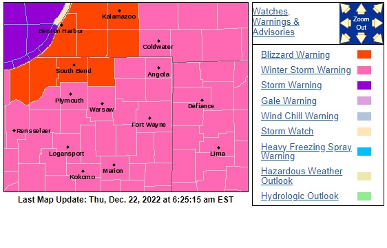
The National Weather Service has issued a Blizzard Warning for St. Joseph, Elkhart, LaPorte, Berrien Cass, and St. Joseph County in Michigan and a Winter Storm Warning for the entire listening area.
The warnings begin on Thursday afternoon and last through early Saturday afternoon. Temperatures will crash by late Thursday afternoon and a rain/snow mix will quickly turn to all snow.
Travel will be very difficult to impossible by early Thursday evening.
In the South Bend area, snow totals of 6 to 12 inches are expected with greater amounts possible closer to the lake.
Widespread blowing and drifting snow will reduce visibility by early Friday morning. Then, there are the weather side-effect:
Gusty winds could bring down tree branches and cause power outages and wind chills as low as 15 below to 30 below zero could cause frostbite on exposed skin in as little as 10 minutes.
URGENT - WINTER WEATHER MESSAGE
National Weather Service Northern Indiana

BLIZZARD WARNING NOW IN EFFECT FROM 4 PM EST /3 PM CST/ THIS
AFTERNOON TO 1 PM EST /NOON CST/ SATURDAY...

* WHAT...Blizzard conditions expected. Total snow accumulations
  of 6 to 12 inches. Winds gusting as high as 55 mph.

* WHERE...Portions of northern Indiana and southwest Michigan.

* WHEN...From 4 PM EST /3 PM CST/ this afternoon to 1 PM EST
  /noon CST/ Saturday.

* IMPACTS...Travel will be very difficult to impossible.
  Widespread blowing and drifting snow will significantly reduce
  visibility. The hazardous conditions will impact holiday
  travel. Gusty winds could bring down tree branches and cause
  power outages. Dangerously cold wind chills as low as 15 below
  to 35 below zero will cause frostbite on exposed skin in as
  little as 10 minutes.

* ADDITIONAL DETAILS...Additional snow accumulations are expected
  along and north of the toll road Saturday through Sunday.

PRECAUTIONARY/PREPAREDNESS ACTIONS...

Travel should be restricted to emergencies only. If you must
travel, have a winter survival kit with you. If you get stranded,
stay with your vehicle.
If you need to run errands 🛒 Thursday, Friday, or through the holiday weekend – the best chance is today before noon.
Showers move in midday, but heavier precipitation starts by 4 PM, and snow will start to accumulate this evening ❄️🥶 pic.twitter.com/Je7nop3AHb— Maci Tetrick (@mtetrick_wx) December 22, 2022
Your ABC 57 First Warning Neighborhood Weather Center Forecast:
Thursday: Rain/snow. Heavy snow starting in the evening. High 36.
Thursday Night: Snowy. Falling temperatures. Wind gusts up to 40 mph. Low 2.
Friday: Heavy snow ending. Wind gusts 50 mph. Blowing/drifting snow. Cold. High 6.
Saturday: Lake effect snow. Breezy and cold. High 10.
Christmas Day: Mostly cloudy and cold. High 10.