
The forecast is cloudy and quiet through Tuesday. A key factor to watch as the winter storm hits Michiana is how much temperatures rise above freezing. Mid-30s may not seem like much, but it could be warm enough that snowfall is more slushy on roads Wednesday.
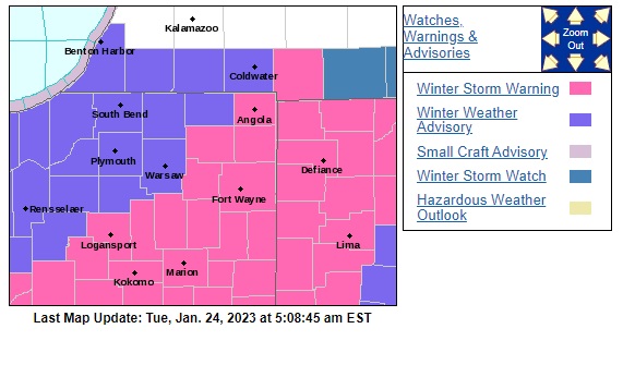
The National Weather Service of Northern Indiana has issued a Winter Weather Advisory for the entire 95.3 MNC listening area for Wednesday. A Winter Storm Warning is in effect for areas southeast of the listening area.
Snow is likely to fall most of Wednesday, starting in the morning and lasting through the afternoon. Most should plan for around four inches, though there is a strong chance 5 to 8 inches of snow in the Warning zone.
The band of heaviest snow looks to be moving through Indiana further to our south, closer to Fulton and Kosciusko Counties, but a shift in this band further to the north or south would greatly impact who sees the most snow from this system. The rest of the week will remain fairly snowy and seasonable temperature-wise.
National Weather Service Northern Indiana
344 AM EST Tue Jan 24 2023

INZ012-103-104-203-204-MIZ078-079-177-277-241645-
/O.NEW.KIWX.WW.Y.0001.230125T0900Z-230126T0100Z/
Starke-Northern La Porte-Eastern St. Joseph IN-Southern La Porte-
Western St. Joseph IN-Cass MI-St. Joseph MI-Northern Berrien-
Southern Berrien-

WINTER WEATHER ADVISORY IN EFFECT FROM 4 AM EST /3 AM CST/ TO
8 PM EST /7 PM CST/ WEDNESDAY.

* WHAT...Snow expected. Total snow accumulations of 3 to 5
  inches.

* WHERE...Portions of northern Indiana and southwest Michigan.

* WHEN...From 4 AM EST /3 AM CST/ to 8 PM EST /7 PM CST/
  Wednesday.

* IMPACTS...Plan on slippery road conditions. The hazardous
  conditions will likely impact the morning and evening commute.

* ADDITIONAL DETAILS...Snow will spread rapidly north early
  Wednesday with rapid accumulations before noon. The snow will
  become lighter during the afternoon, although blowing and
  drifting snow in open areas is likely to persist into the
  evening.
Your ABC 57 First Warning Neighborhood Weather Center Forecast:
Tuesday: Cloudy. High 34.
Wednesday: Snowy High 33.
Thursday: Lake Effect Snow. High 32
Friday: A chance of snow. Mostly cloudy, with a high near 34.
Saturday: A slight chance of snow. Cloudy, with a high near 31.