
Thunderstorm activity ramped back up as a cold front pushed through our area.
A Tornado Watch was put into effect for the entire listening area through 8 p.m, though several counties were removed from the Watch Zone as severe weather passed through.
Several Severe Thunderstorm Warnings were also issued and advised of winds gusts of 80 mph along with golf ball and tennis ball-size hail in spots.
Holy hail! Thank you to our viewers for sending these photos in. #hail pic.twitter.com/VhKEeOvWV7
— ABC57 News (@ABC57News) June 25, 2023
A Tornado Warning that was issued for Starke and Marshall Counties in the 2 p.m. hour was canceled after just a few minutes.
At 4 p.m. on Sunday, Indiana Michigan Power reported around 3,200 outages, most of which, were reported to be in the Benton Harbor/Benton Heights area with a few hundred outages reported in Elkhart and Edwardsburg.
There are some powerlines down and debris near Fir Rd and Redfield Rd. Please use caution. Send us any other storm damage you find in your area! pic.twitter.com/TigkVa9fJR
— ABC57 News (@ABC57News) June 25, 2023
TRACK INDIANA MICHIGAN POWER OUTAGES HERE
A tornado watch has been issued for parts of Indiana, Michigan and Ohio until 8 PM EDT pic.twitter.com/W4lLXClVQf
— NWS Northern Indiana (@NWSIWX) June 25, 2023
The line of storms associated with the front will move out late Sunday night as temperatures drop into the high 50s.
Monday will feature the remnants of the rain in the form of light showers throughout the day and temperatures struggling to make it past the low 70s.
Showers last through Tuesday morning, continuing to cool down Michiana into the high 60s for Tuesday’s high.
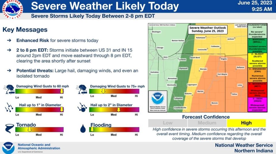
Hazardous Weather Outlook
National Weather Service Northern Indiana
509 AM EDT Sun Jun 25 2023

This Hazardous Weather Outlook is for northern Indiana, southwest
Michigan and northwest Ohio.

.DAY ONE...Today and tonight.

Severe thunderstorms capable of large hail, damaging winds, and a
few tornadoes are possible this afternoon and early evening. The
greatest risk will be in northeast Indiana and northwest Ohio.
Your ABC 57 First Warning Neighborhood Weather Center Forecast:
Sunday: Scattered thunderstorms. High 85.
Monday: Showers. High 73.
Tuesday: AM showers. High 69.