
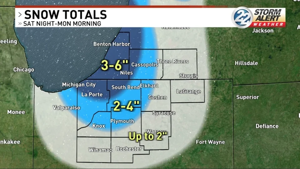
The National Weather Service has issued a Winter Weather Advisory for the Michigan counties of Berrien and Cass, and the Indiana counties of St. Joseph, Elkhart, LaPorte, Marshall and Starke Counties until 1 p.m. on Monday, Feb. 23, for snow accumulating 2″ to 6″, causing hazardous travel conditions, especially for the Monday morning commute.
Light system snow will fall over our entire viewing area most of the day on Sunday, then additional lake effect snows will fall Sunday night through midday Monday.
The snow will begin to melt by mid-week as temps rise into the 40s once again.
URGENT - WINTER WEATHER MESSAGE
National Weather Service Northern Indiana
808 AM EST Sun Feb 22 2026

INZ103-104-203-204-MIZ078-177-277-230115-
/O.CON.KIWX.WW.Y.0008.000000T0000Z-260223T1800Z/
Northern La Porte-Eastern St. Joseph IN-Southern La Porte-Western
St. Joseph IN-Cass MI-Northern Berrien-Southern Berrien-
808 AM EST Sun Feb 22 2026 /708 AM CST Sun Feb 22 2026/

...WINTER WEATHER ADVISORY REMAINS IN EFFECT UNTIL 1 PM EST /NOON
CST/ MONDAY...

* WHAT...Lake effect snow. Additional snow accumulations between 3
  and 5 inches. Winds gusting as high as 30 mph. Blowing and
  drifting of snowfall will be possible.

* WHERE...Portions of northern Indiana and southwest Michigan.

* WHEN...Until 1 PM EST /noon CST/ Monday.

* IMPACTS...Plan on slippery road conditions. Blowing and drifting
  of snow may cause sudden drops in visibilities. The hazardous
  conditions will likely impact the Monday morning commute.

PRECAUTIONARY/PREPAREDNESS ACTIONS...

Slow down and use caution while traveling. The latest road
conditions for the state you are calling from can be obtained by
calling 5 1 1.
A Winter Weather Advisory is in effect through 1 PM EST Mon for: Berrien and Cass Co, MI AND La Porte and St. Joseph Co, IN. Light snow persists through the day today, followed by a period of moderate to heavy lake effect snow Sun PM into Mon near Lake MI pic.twitter.com/mE5zIhd5oy
— NWS Northern Indiana (@NWSIWX) February 22, 2026