
(WSBT Storm Alert Team) Severe weather will take aim at Michiana on Tuesday, March 10.
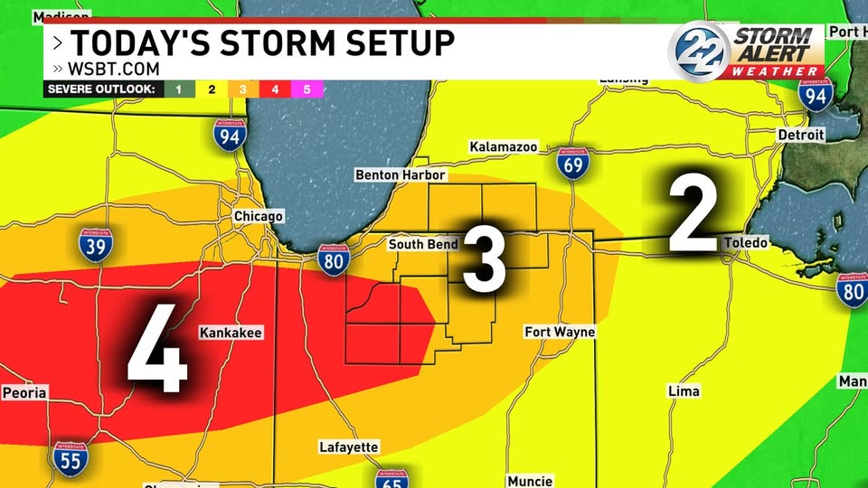
The Storm Prediction Center has placed our western communities under a Level 3 risk.
The cold front associated with this system will arrive Tuesday evening after 5 p.m., and the warmth along with the passing boundary will give us a heightened chance for severe weather.
Our risk for severe weather will be the highest around the middle to late evening, likely from around 8 p.m. into the late evening hours.

All hazards are possible late Tuesday, with the main concerns being tornadoes and large hail.

Have multiple ways to receive alerts. The Storm Alert Weather App is a great option to have on hand. The app will send an alert when a watch or warning is issued, and has live radar to track storms in real time. The app is free to download on the AppStore and Google Play.
Once the storms pass, we will be dealing with widespread rain Wednesday.
Rain totals of 1-2″ are possible for most by Wednesday afternoon, though there could be some higher amounts.

There could be some localized ponding by the end of Wednesday.
Temperatures will also fall Wednesday behind the cold front. Highs Wednesday will be reached early in the day.

We will cool into the 40s and 50s by the end of the week with a few snowflakes possible at times.