
A couple of showers are possible in spots on Monday morning, Aug. 12, but the weather story will be more showers and storms firing up in the afternoon and evening.
Strong-to-severe storms could pop up after 3 p.m. with the best chances happening south and west of the area.
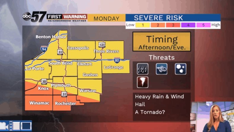
The main threats include heavy rain, strong wind and small hail. The tornado threat looks pretty low with the latest update.
This Hazardous Weather Outlook from the National Weather Service
for northern Indiana, southwest Michigan and northwest Ohio.

Severe thunderstorms and very heavy rainfall are possible Monday
night as a strong system moves across the region. Unfortunately
there is still a high degree of uncertainty with exactly where this
system will track and where the best chances for severe weather and
heavy rain will develop. At this time, it appears the best chance
for
severe weather will be near or south of U.S. 30 with the heavy rain
potential north of this highway. However, this is subject to change
over the next 24 to 36 hours as new data becomes available.

Damaging winds, torrential rainfall and localized flooding
will be the primary hazards but there is a chance for isolated
tornadoes Monday night. Stay tuned to upcoming forecasts for more
information as details become more clear.
Overnight, focus shifts to a heavy rain/flash flooding event as widespread downpours and storms slowly roll through.
Totals of 2-4” are still possible tonight into early Tuesday.
Activity calms down Tuesday morning with brighter skies and cooler highs for much of the work week.
Your ABC 57 First Warning Neighborhood Weather Center Forecast:
Today: Mostly cloudy with a few AM showers and PM showers/storms. High of 84.
Tonight: Mostly cloudy with heavy rain and storms. Flash flooding is possible. Low of 68.
Tuesday: Mostly cloudy with leftover AM showers, then clearing skies. High of 80.
Wednesday: Mostly to partly sunny with a slight chance of a PM pop-up shower or storm. Highs in the upper 70s.