
A Winter Storm Warning is in effect through Sunday evening.
WINTER STORM WARNING REMAINS IN EFFECT UNTIL 7 PM EST /6 PM CST/
THIS EVENING...

* WHAT...Bands of moderate to briefly heavy lake effect snow.
  Additional snow accumulations between 2 and 4 inches possible.
  Winds gusting as high as 35 mph leading to some blowing and
  drifting snow.

* WHERE...Portions of northern Indiana and southwest Michigan.

* WHEN...Until 7 PM EST /6 PM CST/ this evening.

* IMPACTS...Plan on slippery road conditions.

* ADDITIONAL DETAILS...A lull in the snow heavier snow showers is
  expected early this morning, but a transition to lake effect snow
  showers is expected today.
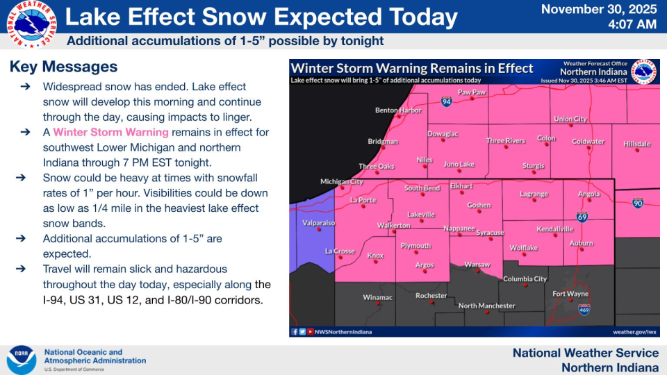
The National Weather Service has issued a WINTER STORM WARNING for Berrien, Cass, LaPorte, Elkhart, LaGrange, Starke, Marshall, Kosciusko, Pulaski, Fulton and St. Joseph Counties in Michigan and Indiana until 7 p.m. Sunday.
CHECK OUT SNOWFALL TOTALS HERE

During the afternoon and evening hours on Sunday, there could be a few lake effect snow showers moving through.
When it is all said and done, there will be widespread areas with 8 to 10 inches of snow, some could see more.

If you have to travel while the storm comes through, make sure you leave your destination early, as well as take your time on the roads, leaving plenty of distance between you and everyone else.

If you have to travel while the storm comes through, make sure you leave your destination early, as well as take your time on the roads, leaving plenty of distance between you and everyone else. (WSBT Photo)
The roads will be covered in snow, which will make driving conditions slippery and slick.
The temperatures at the start of next week will have a sudden surge of arctic air.

The temperatures at the start of next week will have a sudden surge of arctic air. (WSBT Photo)
The temperatures on Monday will be in the mid-20s, and the lows could be in the low teens.
1 comment
And here I am in Florida all bundled up because it’s 62° and freezing outside.