
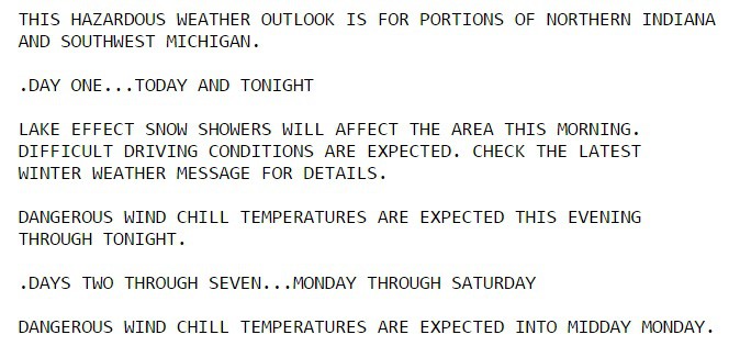
From the National Weather Service: Lighter snow accumulations and impacts are expected on Sunday afternoon, Dec. 18, across far northern Indiana and southwest Lower Michigan as lake effect snows diminish.
The rest of the region will be see mainly dry and cold conditions with many untreated roads still slick and hazardous this morning.
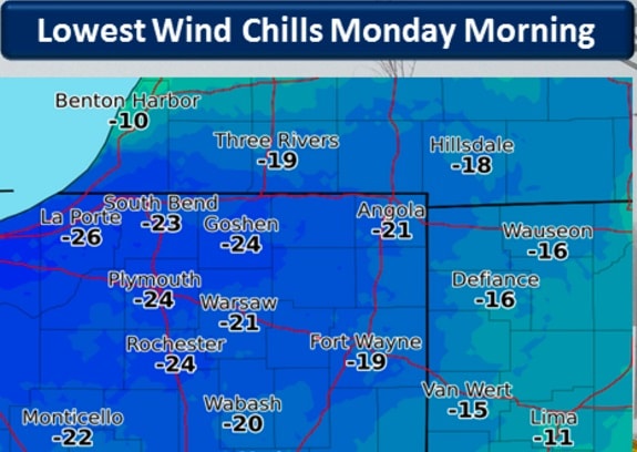
Tonight into Monday morning will feature sub-zero temperatures and dangerous wind chills between -10 and -30 degrees.
A quieter weather pattern is then expected Tuesday through the remainder of the week as temperatures trend warmer and closer to normal.
Here’s a look at the 24 hour snowfall totals! This includes yesterday morning’s snow as well. However, the bulk came from the L.E.S. this AM pic.twitter.com/eGzFC8h4RC
— Shea Sorenson (@Shea_Sorenson) December 18, 2016
⚠️?Record Lows in Jeopardy Tonight. |12/19| 1️⃣-9 in 1983 2️⃣-8 in 1963 3️⃣-8 in 1901 ☃️#INwx #SouthBend. Dangerous Cold!
— Tom Coomes (@TomCoomes) December 18, 2016
⚠️? In case you were wondering the coldest recorded low in #SouthBend is -22° [1/20, 1943, 1/26 1897] More recent -19° [ 1/16, 1999] #INwx
— Tom Coomes (@TomCoomes) December 18, 2016