

The National Weather Service of Northern Indiana has issued a Winter Weather Advisory from 11 p.m. Saturday – 1 p.m. on Sunday, Feb. 11.
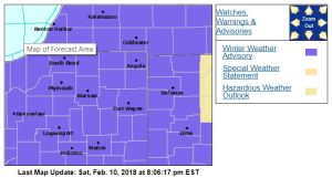
Snowfall of 3″ to 5″ inches is expected to fall in the 95.3 MNC listening area during the advisory period, making travel somewhat difficult.
A mix of snow, sleet and freezing rain is expected south of Michiana and toward Fort Wayne.
Northern Indiana isn’t the only part of the state to get hit by winter weather on Sunday. A Winter Weather Advisory is issued for most for the early portion of the day.
From the National Weather Service of Northern Indiana:
WINTER WEATHER ADVISORY IN EFFECT FROM 1 AM EST /MIDNIGHT CST/
TO 1 PM EST /NOON CST/ SUNDAY...

* WHAT...Snow expected. Total snow accumulations of 3 to 5 inches
  are expected.

* WHERE...Portions of northern Indiana, southwest Michigan and
  northwest Ohio.

* WHEN...From 1 AM EST /midnight CST/ to 1 PM EST /noon CST/
  Sunday.

* ADDITIONAL DETAILS...Plan on slippery road conditions. Be
  prepared for reduced visibilities at times.

PRECAUTIONARY/PREPAREDNESS ACTIONS...

A Winter Weather Advisory for snow means periods of snow will
cause primarily travel difficulties. Be prepared for snow covered
roads and limited visibilities, and use caution while driving.
Wednesday we finally have a chance to get warmer air in, but with some snow pack, that may cool temps at the surface a bit. We’ll also have to see if it comes with chances for rain allowing for the possibility of clouds. Above normal temp days? Need to get rid of the snow first.
— NWS Northern Indiana (@NWSIWX) February 10, 2018