
The threat of severe weather turned reality for Michiana on Monday, May 27, as multiple Tornado Warnings were issued for St. Joseph County, as well as Elkhart, LaPorte, Marshall, Starke and Fulton Counties in Indiana and Berrien and Cass Counties in Michigan.
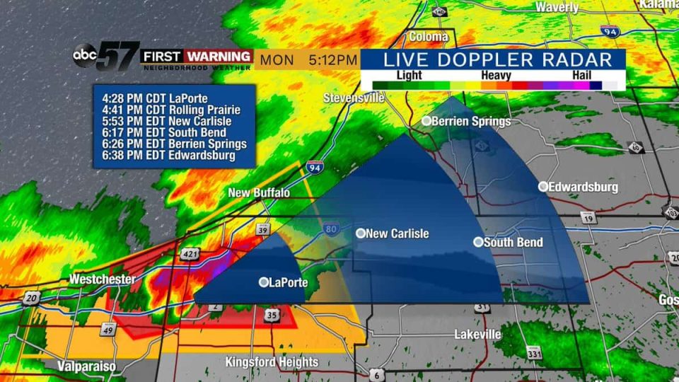
The tornado threat hit the region shortly before 5 p.m. in LaPorte County and continued to move eastward toward St. Joseph County.
Around 5:15 p.m. our reporting partners at ABC 57 reported a tornado-capable storm in the area of U.S. 20 and State Road 23.
95.3 MNC interrupted regular programming for more than two hours and multiple storm cells with rotation resulted in continued Tornado Warnings being issued by the National Weather Service.
There was no immediate confirmation that a tornado had struck in St. Joseph County.
There were no immediate reports of widespread damage.
Power outages in the area were at a minimum, as well, with around 350 Indiana Michigan Power customers left in the dark. NIPSCO reported around 2,000 customers without electricity, but most were in northwestern Indiana. More than 750 people were left without power in the Akron area.
Listeners to 95.3 MNC reported high winds, light debris in the air, as well as heavy rain and hail in the area of U.S. 20 and State Road 23.
Around 8:05 p.m. the National Weather Service confirmed a large tornado on the ground in Fulton County and issued the following information:
The National Weather Service in Northern Indiana  has issued a

* Tornado Warning for...
  Northwestern Wabash County in north central Indiana...
  Eastern Fulton County in north central Indiana...
  South central Kosciusko County in north central Indiana...
  North central Miami County in north central Indiana...

* Until 830 PM EDT.

* At 806 PM EDT, a confirmed large and extremely dangerous tornado
  was located near Akron, or 11 miles east of Rochester, moving east
  at 25 mph.

  This is a PARTICULARLY DANGEROUS SITUATION. TAKE COVER NOW!

  HAZARD...Damaging tornado.

  SOURCE...Radar confirmed tornado.

  IMPACT...You are in a life-threatening situation. Flying debris
           may be deadly to those caught without shelter. Mobile
           homes will be destroyed. Considerable damage to homes,
           businesses, and vehicles is likely and complete
           destruction is possible.

* The tornado will be near...
  North Manchester around 830 PM EDT.
A Tornado Watch remained in effect until 10 p.m. on Monday evening. A Flash Flood Warning remained in effect until 10:30 p.m.
I spoke with a woman who was home at the time of the tornado.
She is a caretaker for a woman, who lives just before this line of trees restricting access to county residents, hear her story tonight at @ABC57News at 10/11. pic.twitter.com/1yRQW3Fh5L
— Kylie Walker (@kylieABC57) May 28, 2019
Images from Akron, IN, where NWS confirmed a large tornado touched down around 8 p.m.
As of now, the amount of damage is unknown. Several trees are blocking access to reports of destroyed homes. pic.twitter.com/CFV6WXOrmu
— Kylie Walker (@kylieABC57) May 28, 2019