
An Excessive Heat Watch goes into effect at 12 p.m. on Monday, June 13 and last until Wednesday night, June 15.
EXCESSIVE HEAT WATCH IN EFFECT FROM NOON EDT /11 AM CDT/ TODAY
THROUGH WEDNESDAY EVENING...

* WHAT...Dangerously hot conditions with afternoon and evening heat
  index values up to 110 possible.

* WHERE...Portions of northern Indiana south of a line from South
  Bend to Bluffton.

* WHEN...From noon EDT /11 AM CDT/ today through Wednesday
  evening.

* IMPACTS...Extreme heat and humidity will significantly
  increase the potential for heat related illnesses,
  particularly for those working or participating in outdoor
  activities.

* ADDITIONAL DETAILS...Heat indices will be around 100 to 105 this
  afternoon and then rise to between 100 and 110 Tuesday and
  Wednesday. This Watch will likely be upgraded to an Excessive
  Heat Warning.

PRECAUTIONARY/PREPAREDNESS ACTIONS...

Monitor the latest forecasts and warnings for updates on this
situation. Be prepared to drink plenty of fluids, stay in an air-
conditioned room, stay out of the sun, and check up on relatives
and neighbors.

Young children and pets should never be left unattended in
vehicles under any circumstances. This is especially true during
warm or hot weather when car interiors can reach lethal
temperatures in a matter of minutes.
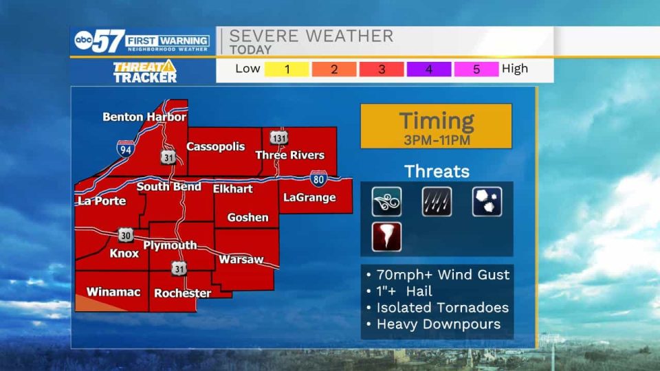
The overall trend shows everyone has the chance to see storm activity here in Michiana. Any storm that does develop this afternoon will have strong to severe potential. Severe threats include; damaging wind gusts up to 75+mph, large hail, heavy downpours, and isolated tornadoes. Storm activity will linger into the evening for most, but another round can’t be ruled out again closer to midnight for portions of southwest Michigan.
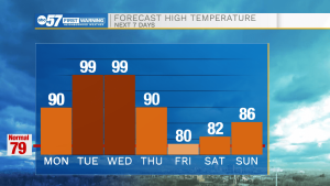
Heat becomes a big concern for Tuesday and Wednesday. High temperatures will top out in the upper 90s to potentially 100. The heat index will range from 105-110. Make sure to limit time outside and stay hydrated.
Thursday afternoon temperatures will fall back into the lower 90s with a chance for a few afternoon thunderstorms. We will keep dropping temperatures into the low to mid 80s heading into the weekend.
Your ABC 57 First Warning Neighborhood Weather Center Forecast:
Monday: Afternoon strong-to-severe storms likely. High 90.
Tuesday: Extreme heat. High 99.
Wednesday: Extreme heat. High 99.
Thursday: Mostly sunny and hot, with a high near 92.
Friday: Sunny, with a high near 82.
Saturday: Sunny, with a high near 84.