
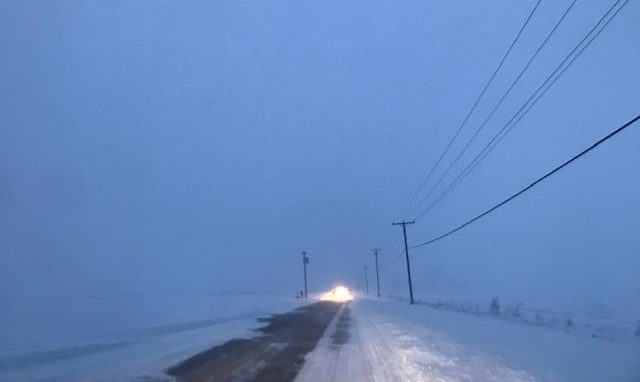
We are currently in the worst of this winter storm with snow still falling, gusty winds resulting in blowing snow/reduced visibility, and icy roads. There are three main concerns this weekend to pay attention to: snow, winds, and bitterly cold temperatures.
Lake-enhanced system snow continues to move its way out this morning with lake-effect snow continuing into tonight. Many areas could see between 1-3 inches, more is likely further north where lake-effect plays a role – up to 4 inches is possible mainly in SW Michigan.
Expect windy conditions all day long, likely gusting up to 45 mph at times. Winds out of the west will make blowing snow an issue, especially on North-South oriented roads. Winds today will also make power outages a possibility, which becomes even more concerning when factoring in the Arctic air intrusion on its way.
Sunday brings more lake effect to northern Michiana, but more notable, will be the bitter cold temperatures. A wind chill advisory goes into effect at midnight tonight, highs will stay in the single digits tomorrow through Tuesday. Daytime wind chills are expected to stay below zeros, nightly wind chills could get as low as -25.
...WINTER STORM WARNING REMAINS IN EFFECT UNTIL 7 PM EST /6 PM
CST/ THIS EVENING...
...WIND CHILL ADVISORY IN EFFECT FROM MIDNIGHT EST /11 PM CST/
TONIGHT TO 1 PM EST /NOON CST/ SUNDAY...

* WHAT...For the Winter Storm Warning, heavy snow. Additional
  snow accumulations of 1 to 3 inches for La Porte and St Joseph
  Counties in Indiana, and 2 to 4 inches for St. Joseph County in
  Michigan. Winds gusting as high as 45 mph today, which will
  cause blowing and drifting snow. For the Wind Chill Advisory,
  very cold wind chills expected. Wind chills as low as 25 below
  zero tonight into early Sunday.

* WHERE...In Indiana, Northern La Porte, Eastern St. Joseph IN,
  Southern La Porte and Western St. Joseph IN Counties. In
  Michigan, St. Joseph MI County.

* WHEN...For the Winter Storm Warning, until 7 PM EST /6 PM CST/
  this evening. For the Wind Chill Advisory, from midnight EST
  /11 PM CST/ tonight to 1 PM EST /noon CST/ Sunday.

* IMPACTS...Plan on slippery road conditions. Blowing snow could
  significantly reduce visibility. The cold wind chills could
  cause frostbite on exposed skin in as little as 30 minutes.

* ADDITIONAL DETAILS...Additional minor snow accumulations are
  possible from lake effect tonight into Sunday.

PRECAUTIONARY/PREPAREDNESS ACTIONS...

If you must travel, keep an extra flashlight, food, and water in
your vehicle in case of an emergency.

Use caution while traveling outside. Wear appropriate clothing, a
hat, and gloves.
Saturday: Snow and wind. Temperatures fall from 27.
Satursday Night: Bitter cold. Snow showers and wind. Low 2.
Sunday: Bitter Cold. Lake effect snow showers. High 4.
Monday: Bitter Cold. Lake effect snow showers. High 4.