
Heavy rain is likely this weekend with the possibility of flash flooding, according to ABC 57 Meteorologist Tom Coomes.
The weather pattern turns from mild to soggy with the heaviest rain falling Saturday night into Sunday. As temperatures cool into next week, freezing rain is a possibility Monday.
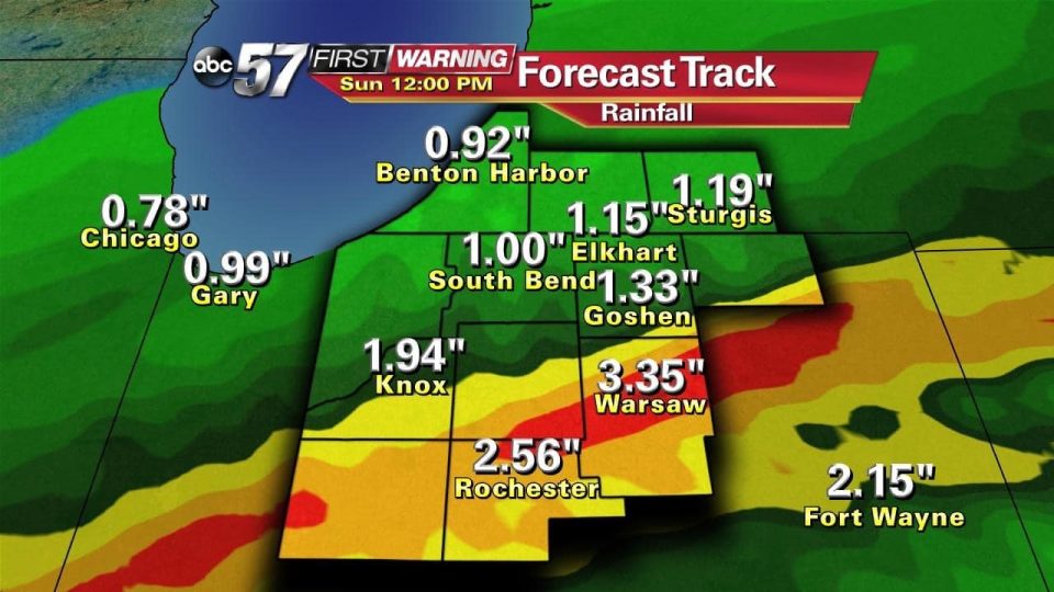
A Flash Flood Watch was posted for counties south of U.S. 6. Rain is expected to continue through Sunday morning.
The heaviest rain will fall Saturday evening, through noon Sunday the latest short-range models have 1″ to 2″ north of U.S. 6 and 2″ to possibly some isolate areas of 3″ south. There is a concern for flooding and flash flooding with so much rain possible in a short period of time.
Freezing rain is possible Sunday night into Monday.
- Saturday night: Rain continues with overnight lows into the upper 30s.
- Sunday: Rainy, highs in the low 40s.
- Monday: Freezing rain possible in the early morning before it changes over to a rain/snow mix. Windy with gusts up to 40mph. Highs in the mid to upper 30s.
- Tuesday: Chance of light rain/snow mix, otherwise mostly cloudy with highs near 40°.
- Wednesday: Lake effect snow flurries possible, highs in the upper 30s.
For Severe Weather Text Alerts direct to your cell phone, text NEWS to 45364.