ABC 57 METEOROLOGIST TOM COOMES BLOG: UPDATE FRIDAY MIDNIGHT:
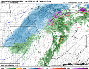
Latest model day is in, showing what could be a nasty line of storms from Kokomo area to Angola. If this scenario were to verify the risk would be from South Bend / US-31 east into Elkhart, Kosciusko and La Grange counties after 3 p.m.
(AP) More than 50 million people are being warned to watch for high winds and possibly tornadoes as a storm system that pummeled California this week moves into the Midwest.

The severe weather will ramp up Friday from Detroit to Nashville, Tennessee. Meteorologist Patrick Marsh of the Storm Prediction Center in Norman, Oklahoma, says the atmosphere is operating as though it is spring even though the calendar says it is still winter.
Latest weather briefing for severe weather potential today & tonight. https://t.co/RKvbdnd6KI
— NWS Northern Indiana (@NWSIWX) February 24, 2017
Moist air from the Gulf will send temperatures toward 70 in northern Indiana and southern Michigan on Friday — or about 30 degrees above normal. Marsh cautioned that residents of the area should expect storms more typical of April or May.
Heavy rains hit California this week, causing floods around San Jose. The same storm system is expected to bring snow to other parts of the Midwest.
For severe weather text alerts to your cell phone, text NEWS to 45364.
Severe weather likely today, especially strong winds, but large hail and isolated tornadoes are also possible from North IN, NW OH, MI . pic.twitter.com/iyGc24zKp8
— NWS Northern Indiana (@NWSIWX) February 24, 2017

