
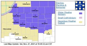
A Winter Weather Advisory has been issued for a portion of the 95.3 MNC listening area.
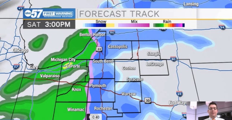
Saturday will be cloudy and chilly across Michiana with a few rain and snow showers moving through by the afternoon. As temperatures fall tonight, a few more flurries or snow showers are possible into Sunday morning. Impacts look to be very minor across Michiana from this latest round of winter weather. We’ll have to watch for a little freezing drizzle possible late Saturday in isolated areas in Michigan. Any snow accumulations will be less than an inch for our area, but west and southeast Michigan could pick up 2-3″ of snow, so keep that in mind if you’re traveling back that way Sunday.
St. Joseph-Elkhart-Lagrange-Steuben-Noble-De Kalb-Marshall-
Kosciusko-Whitley-Allen-Berrien-Cass

WINTER WEATHER ADVISORY IN EFFECT FROM 3 PM THIS AFTERNOON TO
10 AM EST SUNDAY

* WHAT...Mixed precipitation expected. Total snow accumulations
  will be less than one inch. Ice accumulations of a light glaze.

* WHERE...Portions of northern Indiana, southwest Michigan and
  northwest Ohio.

* WHEN...From 3 PM this afternoon to 10 AM EST Sunday.

* IMPACTS...Plan on slippery road conditions.

* ADDITIONAL DETAILS...Mainly rain is expected this afternoon, but
  snow and sleet will mix in at times. Light freezing rain and
  drizzle will be possible this evening and overnight causing
  hazardous driving conditions.

PRECAUTIONARY/PREPAREDNESS ACTIONS...

Slow down and use caution while traveling.
Next week looks very quiet as highs move slowly through the 40s to end November. We’ll be nearing 50 degrees for the first few days of December with a few showers possible on Friday.
Your ABC 57 First Warning Neighborhood Weather Forecast
Saturday: Cloudy and chilly. Rain/snow showers possible by the afternoon. High 38.
Saturday Night: Rain and snow showers. Isolated freezing drizzle possible. Low 32.
Sunday: A few snow showers in the morning, then mostly cloudy. Temps steady in the 30s. No significant snow accumulation expected.
Monday: Cloudy. High 40.