
Snow showers will mostly clear out by mid-morning on Sunday. Isolated lake effect snow will be possible throughout the day. Finally, Sunday night snow chances will clear and then we are left with bitter cold temperatures. Highs Sunday afternoon will only top out in the upper 20s. Lows Monday morning will drop into the single digits for some. Highs will slowly warm back into the 30s for the middle of the week, but then another round of snow and bitter cold moves in Wednesday into Thursday.
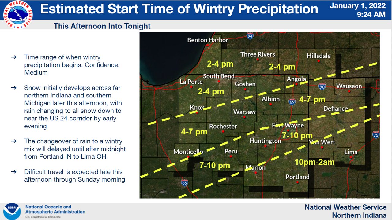
If you are traveling to other parts of Indiana, expect a lot precipitation, as well.
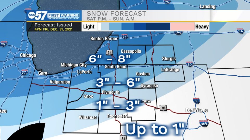
“That area between, say, a line from Knox to Goshen, and then north of U.S. 24…that’s kind of our ‘uncertain zone’ at this point,” said Meteorologist Chris Roller with the National Weather Service of Northern Indiana. “Northeast Indiana could get more of a wintry mix, making the snowfall totals lower.”
“I got a 1-3 inch snowfall total in Warsaw, about 1-2 inches in Fort Wayne,” Roller said.
Central portions of Indiana can expect mostly rain on Saturday, although Roller doesn’t rule out the possibility of it changing to a light snow on Saturday night.
Southern Indiana will be dealing with flooding, as areas along the Ohio River could get 2-3 inches of rain this weekend.
The temperatures are the other key ingredient to this weekend’s weather system. Roller says even if your area only gets rain for most of Saturday, the temperatures will drop low enough to make roads slick.
“One of those things where you’ll want to drive around with some caution Saturday night and into Sunday.”
It will be windy across the entire state on Sunday, making feel-like temperatures in the upper 20s or low 30s for the southern half of the state, and in the teens for the northern half.
Including the cities of Michigan City, La Porte, South Bend,
Mishawaka, New Carlisle, Walkerton, Niles, Benton Harbor,
St. Joseph, Fair Plain, Benton Heights, Buchanan, Paw Paw Lake,
Dowagiac, Cassopolis, Edwardsburg, and Marcellus
316 PM EST Fri Dec 31 2021 /216 PM CST Fri Dec 31 2021/

...WINTER WEATHER ADVISORY IN EFFECT FROM 1 PM EST /NOON CST/
SATURDAY TO 7 AM EST /6 AM CST/ SUNDAY...

* WHAT...Snow expected. Total snow accumulations of 4 to 7
  inches. Locally higher amounts possible, especially near Lake
  Michigan.

* WHERE...In Indiana, La Porte and St. Joseph Counties. In
  Michigan, Berrien and Cass Counties.

* WHEN...From 1 PM EST /noon CST/ Saturday to 7 AM EST /6 AM
  CST/ Sunday.

* IMPACTS...Travel could be very difficult.

* ADDITIONAL DETAILS...Snow, possibly mixed with rain at the
  start, will develop Saturday afternoon and may become heavy at
  times late Saturday afternoon into Saturday evening.

PRECAUTIONARY/PREPAREDNESS ACTIONS...

Slow down and use caution while traveling.
Your ABC 57 First Warning Neighborhood Weather Center Forecast:
Overnight Sunday morning: Several inches of snow will continue to fall. 6-8 inches are possible in northwestern St. Joseph County, Berrien County and Cass County.
Sunday: A few snow showers possible in the morning. Cold and breezy. High 25.
Monday: Sunny, with a high near 24.
Tuesday: Mostly sunny, with a high near 35.
Wednesday: A 30 percent chance of afternoon snow showers. Mostly cloudy, with a high near 30.
Thursday: Snow likely. Mostly cloudy, with a high near 24.
Friday: A slight chance of snow showers. Mostly cloudy and cold, with a high near 19.
1 comment
[…] Winter Weather Advisory in effect through early Sunday morning 953mnc.com […]