
(Dave Caulfield/ABC 57 Meteorologist) Temperatures will remain in teens with feels like temps near or below zero into Thursday morning, Jan. 6.
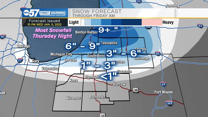
Light lake-effect continues tonight, and parts of Michiana will see more lake-effect snow Thursday.
The bulk of any snow accumulation will occur Thursday night as a band sets up across southwestern Michigan.
Northern Indiana north of the toll road could also pick up a few inches of accumulation during this time as well.
While the snow wraps up Friday, the cold does not. Highs will only be in the teens Friday, with lows in the single digits.
Saturday will be milder, but a round of rain/snow/sleet is possible Saturday night into Sunday morning. We’ll do this all over again (falling temps, windy, cold) Sunday and Monday.
Your ABC 57 First Warning Neighborhood Weather Center Forecast:
Thursday: Partly sunny, breezy and cold. Lake-effect snow possible, especially for SW MI. High 20.
Friday: Snow wraps up around lunchtime, then decreasing clouds and very cold. High 18. Wind chills down to -5.
Saturday: Mostly cloudy and milder. High 35.
Sunday: Mostly cloudy, with a high near 36.
Sunday Night: Mostly cloudy, with a low around 9.
Monday: A 20 percent chance of snow showers. Mostly cloudy and cold, with a high near 17.
Monday Night: Mostly cloudy, with a low around 9.
Tuesday: Mostly sunny, with a high near 24.
Wednesday: Partly sunny, with a high near 36.